Challenges
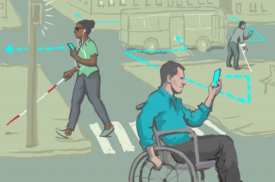
Make an application that maps accessibility information and allows the users to add new information about cities and points of interest. The application should include a social feed that searches for georeferenced posts, tweets, etc... associated with a set of keywords and shows the results in a tab and/or maps them all together.
The goal is to develop a game (doesn't have to be on a mobile platform) where the player classifies Sentinel-2 image pixels.
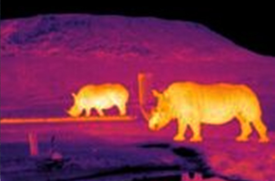
A key part of the system is developing software to automatically detect and identify animals and humans in aerial thermal video footage.
Develop a tool to allow young people living in the Arctic to engage with satellite images, weather data and in-situ observations in new ways, to promote sharing of information with their Elders and help to identify data that could be used to predict environmental hazards.
Develop a biodiversity monitoring tool to motivate local patrols in Madagascar to engage with satellite images and encourage them to contribute in-situ observations. Clear evidence of illegal activities per location/fokontany/village is urgently needed to improve law enforcement and natural resource management. Georeferenced in-situ data could provide authorities and regional government services with useful data to halt deforestation.
There is variation in the level of malnourished children in Sudan at the level of the states. The challenge involves using satellite images together with open source geographical data to understand the spatial disparity/patterns of malnutrition between states.
#SDG11 #InclusiveCities #AccessibileCities #SocialInclusion
Challenge Description:
Make an application that maps accessibility information and allows the users to add new information about cities and points of interest. The application should include a social feed that searches for georeferenced posts, tweets, etc... associated with a set of keywords (such as #accessibility) and shows the results in a tab and/or maps them all together.
Background:
Why do cities need to be inclusive and accessible? According to the World Health Organization, about 15% of the world's population lives with an impairment or disability. As the world's population increases more people will live in cities, and as cities grow in size we need to think about how they are built and who they are for. Many of the cities in Europe are proud of their history, and while winding alleys and cobbled roads are beautiful, they are not very friendly to those who are less mobile. There has typically been a lack of focus on accessibility in the past, however, that is all changing. If cities are built with accessibility in mind people with disabilities will be able to enjoy these cities from every angle as they aim for a more inclusive experience. When we design for disability, we all benefit!
It is important to note that a city does not become accessible only by adapting its structures and development to suit all needs. Social inclusion is also key in providing equal conditions for everyone. In the search for an "inclusive society", activists and advocates for the world's disability related issues have found a unique and powerful home on the social media platforms (Twitter, Facebook, etc...), using to connect, educate, and share opportunities to create and pursue social change.
This challenge addresses the following Sustainable Development Goals (SDGs), adopted by the United Nations General Assembly:
Goal 11.2: By 2030, provide access to safe, affordable, accessible and sustainable transport systems for all, improving road safety, notably by expanding public transport, with special attention to the needs of those in vulnerable situations, women, children, persons with disabilities and older persons.
Goal 11.3: By 2030, enhance inclusive and sustainable urbanization and capacity for participatory, integrated and sustainable human settlement planning and management in all countries.
Goal 11.7: By 2030, provide universal access to safe, inclusive and accessible, green and public spaces, in particular for women and children, older persons and persons with disabilities.
Goal 11.b: By 2020, substantially increase the number of cities and human settlements adopting and implementing integrated policies and plans towards inclusion, resource efficiency, mitigation and adaptation to climate change, resilience to disasters, and develop and implement, in line with the Sendai Framework for Disaster Risk Reduction 2015-2030, holistic disaster risk management at all levels.
Recommended Specifications:
Resources:
https://access.earth/ - Example of Accessibility Map (with landmarks only for the most part)
Resources: Example of data for inclusive cities
Sweden, Stockholm: https://goo.gl/5jCcpg
Denmark, Copenhagen: https://goo.gl/3uHRtT
Italy, Roma: https://goo.gl/WoSMeM
Austria, Vienna: https://goo.gl/dK2rSW
Italy, Milan: https://goo.gl/xsd7e8
Holland, Amsterdam: https://goo.gl/sx4npF
Germany, Munich: https://goo.gl/MLTwhn
Challenge submitted by: Alessio Torraco, European Space Agency
Challenge Description:
The goal is to develop a game (doesn't have to be on a mobile platform) where the player classifies Sentinel-2 image pixels.
Background:
Machine learning techniques are a promising approach to advance cloud detection algorithms. In order to obtain high accuracy in detecting clouds with machine learning algorithms, a reliable data base has to be used to train the neural network. Up to date, there is a general lack of such data bases with reliably classified pixels. Probably the most reliable way to overcome this issue would be classification by eye, but this is a rather tedious task. A game where the user/player classifies pixels in an entertaining way could counteract the boredom in this task. Imagery will be taken from ESA's Sentinel-2 satellites, Sentinel-2 A and B.
Sentinel-2 is an Earth observation mission developed by ESA as part of the Copernicus Programme to perform terrestrial observations in support of services such as forest monitoring, land cover changes detection, and natural disaster management. It consists of two identical satellites built by Airbus DS, Sentinel-2A and Sentinel-2B. The Sentinel-2 satellites each carry a single multi-spectral instrument (MSI) with 13 spectral channels in the visible/near infrared (VNIR) and short wave infrared spectral range (SWIR).
This challenge addresses the following Sustainable Development Goals (SDGs), adopted by the United Nations General Assembly:
Goal 4.4: By 2030, substantially increase the number of youth and adults who have relevant skills, including technical and vocational skills, for employment, decent jobs and entrepreneurship.
Goal 13.1: Strengthen resilience and adaptive capacity to climate-related hazards and natural disasters in all countries.
Goal 13.3: Improve education, awareness-raising and human and institutional capacity on climate change mitigation, adaptation, impact reduction and early warning.
Recommended Specifications:
The game has to include the following categories for the pixels: Thin cloud, thick cloud, cloud shadow, snow, land, water.
Resources:
Sentinel-2 datasets:
Sentinel Hub blog about cloud detection and machine learning:
https://medium.com/sentinel-hub/improving-cloud-detection-with-machine-learning-c09dc5d7cf13
Already existing application for users to classify pixels by Sentinel Hub:
https://www.sentinel-hub.com/blog/crowdsourcing-eo-training-datasets-improve-cloud-detection
https://apps.sentinel-hub.com/classificationApp-trial/
Challenge submitted by: Fabio Vivian, European Space Agency
Challenge Description:
#SDG13 #ClimateAction #SDG15 #LifeonLand #Conservation #UAVs
Challenge Description:
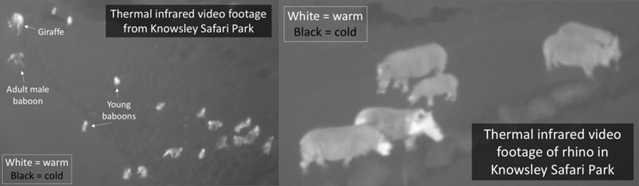
A key part of the system is developing software to automatically detect and identify animals and humans in aerial thermal video footage. We have been working with local zoos and safari parks to build up thermal video libraries of different animals species (see Figure 1 below). At the same time we have been collaborating with conservation agencies (e.g. WWF) to take data of the same species, and also humans masquerading as poachers, in the wild. The GEOSS/Hack 2018 challenges is in three parts:
Background:
The World Wildlife Fund for Nature (WWF) estimates that up to five species of life on our planet become extinct every day. A recent study compiling surveys of animal populations around the globe shows that this rate of "biological annihilation" means a sixth mass extinction in Earth's history is under way and is more severe than previously feared. This astonishing rate of decline has potentially catastrophic consequences, not just for the ecosystems where the species are lost, but also for the world economy and planet as a whole. The World Bank estimates that ecosystems provide $33 trillion every year to the global economy: more than the GDP of USA and Europe combined. So it is no surprise that at the recent World Economic Forum the top business leaders, international political leaders and intellectuals around the globe identified biodiversity loss and consequent ecosystem collapse as one of the 10 foremost dangers facing humanity, and most pressingly in the developing world. There is a fundamental need to routinely monitor animal populations over much of the globe so that conservation strategies can be optimized with such information.
Summary of wider project aims and objectives:
The challenge faced to meet this need is considerable. To date most monitoring of animal populations is conducted manually, which is extremely labor-intensive, inherently slow and costly. Researchers have started to use unmanned aerial vehicles (UAVs), or drones, with consumer-grade RGB (visible/optical wavelength) cameras for such monitoring. Drones have the advantage of being cheap and easy to deploy and can cover large/inhospitable areas quickly and efficiently. However, using optical cameras on these drones has from two major constraints. Firstly, they do not yield usable images at night, so monitoring is not possible half of the time. Secondly, at visible wavelengths objects have similar brightness, making it extremely difficult to pick out animals in an automated way. In contrast, thermal cameras are sensitive to heat radiation, making it much easier to distinguish warm animals from the cooler background. As such they are ideally suited to facilitate finding and identifying animals, both during the day and at night. Crucially, the falling cost of drones and small, light-weight, high-fidelity thermal cameras that can be attached to those drones now makes systematic thermal monitoring possible and economically viable in developing countries. We are currently working on a system which, in a few years, aims to use drones to provide real-time, geo-tagged monitoring of animals during both day and night over large and/or difficult to reach areas. Satellite and sensor technology are developing so rapidly that on decade timescales it is predicted that the entire surface of the Earth will be imaged every day at a resolution sufficient to detect and identify large animals. Clearly this has the potential to revolutionize the monitoring of such species. The long-term goal of the project is to build upon our drone experience and incorporate satellite imaging in the monitoring process. This GEOSSHACK project represents our first step in this direction.
Recommended Specifications:
The solution to this challenge should be able to run on a standard desktop or laptop computer.
This challenge addresses the following Sustainable Development Goals (SDGs), adopted by the United Nations General Assembly:
Goal 13.1: Strengthen resilience and adaptive capacity to climate-related hazards and natural disasters in all countries.
Goal 15.5: Take urgent and significant action to reduce the degradation of natural habitats, halt the loss of biodiversity and, by 2020, protect and prevent the extinction of threatened species.
Goal 15.7: Take urgent action to end poaching and trafficking of protected species of flora and fauna and address both demand and supply of illegal wildlife products.
Resources:
The data for both challenges and some simple visualization software for viewing the raw thermal data can be found here.
Challenge Submitted by: Steve Longmore, Serge Wich, Claire Burke, Maisie Rashman
#SDG13 #ClimateAction #IndigenousKnowledge #Seaice #Arctic #SDG11 #SustainableCitiesandCommunities #SDG4 #QualityEducation
Challenge Description:
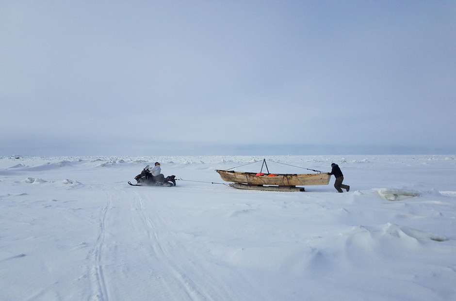
Develop a tool to allow young people living in the Arctic to engage with satellite images, weather data and in-situ observations in new ways, to promote sharing of information with their Elders and help to identify data that could be used to predict environmental hazards.
Background:
The Arctic weather and climate is changing at an unprecedented rate. The young people who are experiencing these changes, together with their Elders and Whaling Captains, are having to learn the new ice regime and how to interact with single season ice, the new ice. In order to adapt to these new changes, education is very important but also cultural awareness. If you don't know how to read ice conditions, you don't know what's going on with the ocean. If you don't know how to do that, it could be a life, health and safety issue.
Interactions with Elders, whaling captains and other crew members create a sense of respect of the culture and are fundamental in transmitting inter-generational knowledge needed to strengthen resilience and adaptive capacity to climate related issues. Furthermore, they instil in the youth a sense of duty to uphold this cultural awareness and uphold the Inupiaq values.
How can satellite images be used as a means to increase Elder-youth interactions and promote cultural awareness?
This challenge addresses the following Sustainable Development Goals (SDGs), adopted by the United Nations General Assembly:
Goal 4.7: By 2030, ensure that all learners acquire the knowledge and skills needed to promote sustainable development, including, among others, through education for sustainable development and sustainable lifestyles, human rights, gender equality, promotion of a culture of peace and non-violence, global citizenship and appreciation of cultural diversity and of culture's contribution to sustainable development.
Goal 11.4: Strengthen efforts to protect and safeguard the world's cultural and natural heritage.
Goal 13.1: Strengthen resilience and adaptive capacity to climate-related hazards and natural disasters in all countries.
Goal 13.3: Improve education, awareness-raising and human and institutional capacity on climate change mitigation, adaptation, impact reduction and early warning.
Recommended Specifications:
Resources:
Challenge submitted by: Gordon Ikayuak Brower, Inupiaq Whaling Captain, Lifelong Arctic Alaska resident, Director of the North Slope Borough department of planning and community services
#SDG11 #SDG13 #SDG17 #ClimateAction #PartnershipfortheGoals #SDG15 #LifeonLand #Madagascar #CommunitybasedMonitoring #Wildlife #Deforestation
Challenge Description:
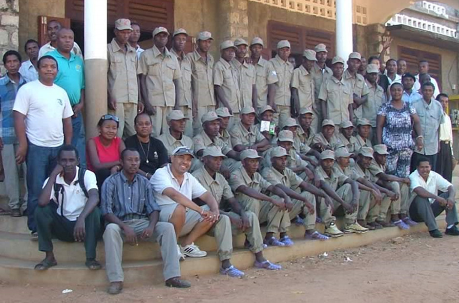
Develop a biodiversity monitoring tool to motivate local patrols in Madagascar to engage with satellite images and encourage them to contribute in-situ observations. Clear evidence of illegal activities per location/fokontany/village is urgently needed to improve law enforcement and natural resource management. Georeferenced in-situ data could provide authorities and regional government services with useful data to halt deforestation.
Background:
Menabe Antimena protected area, 210,000 hectares, located in Western Madagascar 44.661E, 19.985S, was first created in 2006 but received its permanent protection decree in 2015. With 100,000 hectares of dry deciduous forest, 3,000 hectares of lake and 25,000 hectares of mangroves, Menabe is very well known for its high rate of species endemicity and exceptional concentration of baobab trees, attracting more than 3,000 tourists every year. At least three species of wild animals are found only in Menabe: the giant jumping rat Hypogeomys antimena, flat-tailed tortoise Pyxis planicauda and the narrow-striped mongoose Mungotictis decemlineata decemlineata, but it is also home to fosa Cryptoprocta ferrox,the largest carnivore of Madagascar. Menabe is extremely important for biodiversity conservation in Madagascar as it has always been considered as the largest remaining bloc of dry forest in the country, and also hosting 7% of the national mangrove cover, both providing local people with important ecosystem services such as wild yam, fuel wood, pasture, medicinal plants, construction wood, cosmetics, honey, ancestral graves etc.
In 2008, stakeholders and Fanamby NGO, the park manager developed the Menabe protected area management plan and official zoning based on location of key conservation targets and natural resources use by locals. The zoning comprises Strict Conservation Zones (SCZ) which represent about 30% of each management zone. They often have the best quality habitat - best quality forest with high density of large-diameter trees, territories of flagship species.
In our community-based conservation approach adopted in the area since 2002, we helped with the creation of 11 official management contracts around the PA core zones to allow the local community to manage the forest within their traditional terroir. Each of these communities has a local association responsible for the management of the habitat (forest or wetlands) within their traditional terroir, and through these associations we created a programme of community patrollers (currently 168) who are engaged to carry out weekly patrols to collect and report data on key biodiversity and threats.
Current threats:
Deforestation, primarily due to slash-and-burn agriculture and illegal timber exploitation has always been a threat. But in in the last five years, this pressure has increased dramatically with 3-5% of the forest being lost each year. In 2016 and 2017, deforestation is at its highest level and fastest speed causing loss of more than 4,000 hectares of forest annually. If deforestation continues with its current rate and speed, most of Menabe’s native species will be extinct soon. The rapid increase is being driven by increased immigration to the region from drought-stricken areas in Southern Madagascar. Equally, driven by a 150% increase in the price of peanuts paid by Chinese dealers, there has been a massive intensification of clearance for peanut, and maize farming for local brewery. These influxes and the failure of the government, conservation NGOs and authorities to address the problem has de-motivated resident communities and reduced their willingness to engage in conservation. So far, the local convention ‘dina’, recently approved by local communities, stakeholders and the tribunal could not help solve the issue.
We therefore need to focus immediately on supporting the local patrol programme; improving their capacity and effectiveness. Through the patrollers we aim to improve cohesion and belief within the communities that protecting the forest is achievable. We want to facilitate more effective law enforcement and help authorities respond to infractions within the NPA.
How can satellite images or other smartphone/GPS technologies be used to enhance community-based conservation and monitoring to halt deforestation in Menabe Antimena Protected Area, Western Madagascar?
Main challenges faced by our local monitoring system
Considerations:
Possible Features:
This challenge addresses the following Sustainable Development Goals (SDGs), adopted by the United Nations General Assembly:
Goal 11.4: Strengthen efforts to protect and safeguard the world’s cultural and natural heritage.
Goal 13.1: Strengthen resilience and adaptive capacity to climate-related hazards and natural disasters in all countries.
Goal 13.2: Integrate climate change measures into national policies, strategies and planning.
Goal 13.3: Improve education, awareness-raising and human and institutional capacity on climate change mitigation, adaptation, impact reduction and early warning.
Goal 15.c: Enhance global support for efforts to combat poaching and trafficking of protected species, including by increasing the capacity of local communities to pursue sustainable livelihood opportunities.
Goal 15.2: By 2020, promote the implementation of sustainable management of all types of forests, halt deforestation, restore degraded forests and substantially increase afforestation and reforestation globally.
Goal 17.18: By 2020, enhance capacity-building support to developing countries, including for least developed countries and small island developing States, to increase significantly the availability of high-quality, timely and reliable data disaggregated by income, gender, age, race, ethnicity, migratory status, disability, geographic location and other characteristics relevant in national contexts.
Resources:
All areas: https://goo.gl/WJ88Nn
Sentinel 1A: https://goo.gl/9Ukgqe
Sentinel 1B: https://goo.gl/9K5M4K
Sentinel 2A: https://goo.gl/Tzu6ui
Sentinel 2B: https://goo.gl/7eYiB5
Sentinel 3A: https://goo.gl/ZY1K8w
Landsat 8 OLI/TIRS: https://goo.gl/gY7rkp
Global Land Surface Satellite: https://goo.gl/fuLQ41
National Parks (all data)
Mantadia National Park: https://goo.gl/EZ4jwb
Ranomafana National Park: https://goo.gl/U2NM47
Isalo National Park: https://goo.gl/YdDooc
Ankarana National Park: https://goo.gl/D1AQM4
Natural Reserve of Tsingy de Bemaraha : https://goo.gl/G7xFsg
Masoala National Park: https://goo.gl/pcezE3
Midongy Befotaka National Park: https://goo.gl/GUUNFe
Challenge Submitted by: Dr Herizo Andrianandrasana, Durrell Wildlife Conservation Trust Madagascar
#SDG2 #ZeroHunger #SDG3 #GoodHealth #Sudan #Children
Challenge Description:
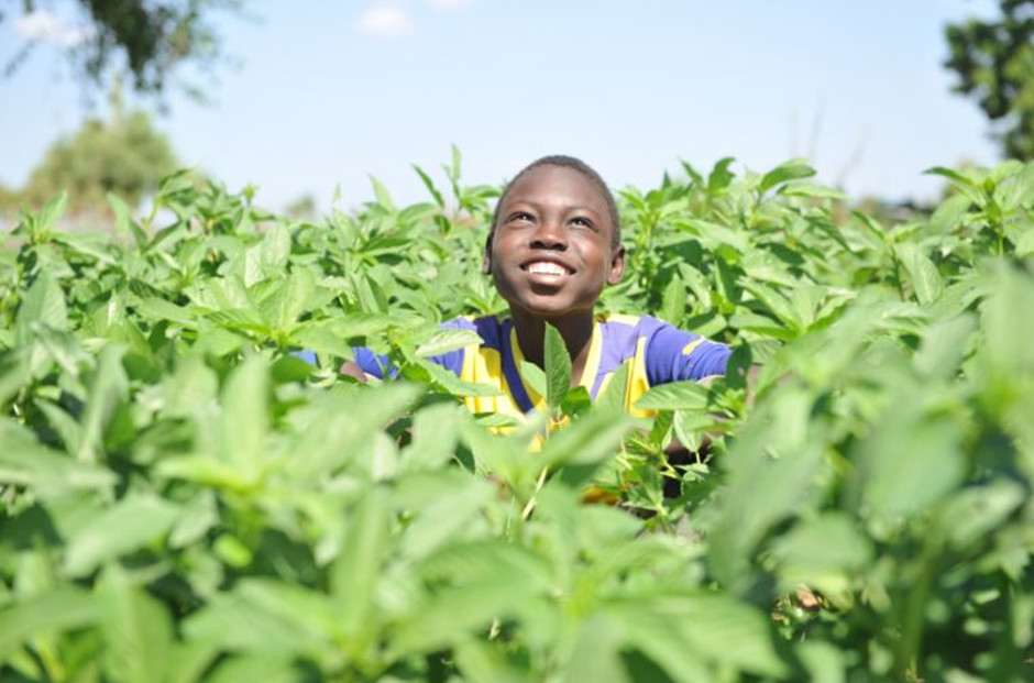
There is variation in the level of malnourished children in Sudan at the level of the states. The challenge involves using satellite images together with open source geographical data to understand the spatial disparity/patterns of malnutrition between states.
Background:
Sudan is a located in North Africa, and is the third largest country in Africa. The River Nile runs across the entire country. It is bordered by Egypt to the north, the Red Sea, Eritrea and Ethiopia to the east, South Sudan to the south, the Central African Republic to the southwest, Chad to the west and Libya to the northwest. The climate differs across the country with rainfall increasing towards the south. This then reflects on the crops and subsequently the diets of the different states. In measuring malnutrition across countries, Sudan ranks as one of the worst in the world. Beyond the immediate danger, the lingering physical and developmental effects of malnourishment can doom a child to a lifetime of complications. The effects are irreversible. Therefore, understanding population at risk will help in setting priorities.
This challenge addresses the following Sustainable Development Goals (SDGs), adopted by the United Nations General Assembly:
Goal 2.1: By 2030, end hunger and ensure access by all people, in particular the poor and people in vulnerable situations, including infants, to safe, nutritious and sufficient food all year round.
Goal 2.2: By 2030, end all forms of malnutrition, including achieving, by 2025, the internationally agreed targets on stunting and wasting in children under 5 years of age, and address the nutritional needs of adolescent girls, pregnant and lactating women and older persons.
Goal 3.2: By 2030, end preventable deaths of newborns and children under 5 years of age, with all countries aiming to reduce neonatal mortality to at least as low as 12 per 1,000 live births and under-5 mortality to at least as low as 25 per 1,000 live births.
Goal 3.d: Strengthen the capacity of all countries, in particular developing countries, for early warning, risk reduction and management of national and global health risks.
Resources:
Khartoum area: (Sudan capital city)
Khartoum area all data: https://goo.gl/Q61HcD
Global Land Surface Satellite: https://goo.gl/RRshSD
Sentinel 1A: https://goo.gl/CyJExz
Sentinel 1B: https://goo.gl/XQUfCH
Sentinel 2A: https://goo.gl/6tbWqm
Sentinel 2B: https://goo.gl/4W2yNM
Sentinel 3A: https://goo.gl/WhxDQc
Landsat 8 OLI/TIRS: https://goo.gl/GuQPue
Challenge submitted by: Dr. Noon Altijani Osman Abbakar
Group on Earth Observations
7 bis, avenue de la Paix
Case postale 2300
CH-1211 Geneva, Switzerland
Tel. +41 22 730 8505
Fax +41 22 730 8520
secretariat@geosec.org
Follow us on:
Group on Earth Observations
7 bis, avenue de la Paix
Case postale 2300
CH-1211 Geneva, Switzerland
Tel. +41 22 730 8505
Fax +41 22 730 8520
secretariat@geosec.org
Follow us on: