

Challenges
1) APP TO RECORD STORIES AND CULTURAL PRACTICES
- Team Name: Global Water Tracker
- Community: Wollotuka Institute (Newcastle NSW)
- Location: Newcastle University (NSW), Australia
- Challenge: Build an app that allows users to record the stories, cultural practices, and names of water in country, share this knowledge with communities across the world, which promotes the preservation of languages and knowledges, to help find ways to solve water management issues globally.
- Challenge Description: An app that uses geotagging to identify water sources across the globe.It will have the ability to record traditional cultural knowledges and practices around water, and share this information with other users.This can include video, recordings of elders (with respect to local cultural protocols) and then other users can compare and share their stories. Language and knowledge preservation is a key element of this project as it will benefit global Indigenous communities.
- Background: Water management and access is a global problem, and Indigenous people have thousands of years’ experience in using and maintaining water in their country. By working with local communities to record and preserve Indigenous knowledge of cultural practices and values around water, we may be able to find sustainable solutions to what is becoming a global problem. This project can also help preserve language and knowledge and allow younger people to learn from elders in their communities.The global focus of this app will also promote co-operation and knowledge sharing across and between Indigenous and non-indigenous groups.
- Recommended specifications: Need to be very aware of cultural protocols concerning sacred sites, men’s business, woman’s business etc. However, GPS location can allow for an appropriate knowledge and warnings if needed when operating the app
- Resources : NB: Aunty Bronwyn Chambers has provided the following information, but does not speak on behalf of all Aboriginal and Torres Strait Islander people. She only gives information that she has been taught, and that she knows.
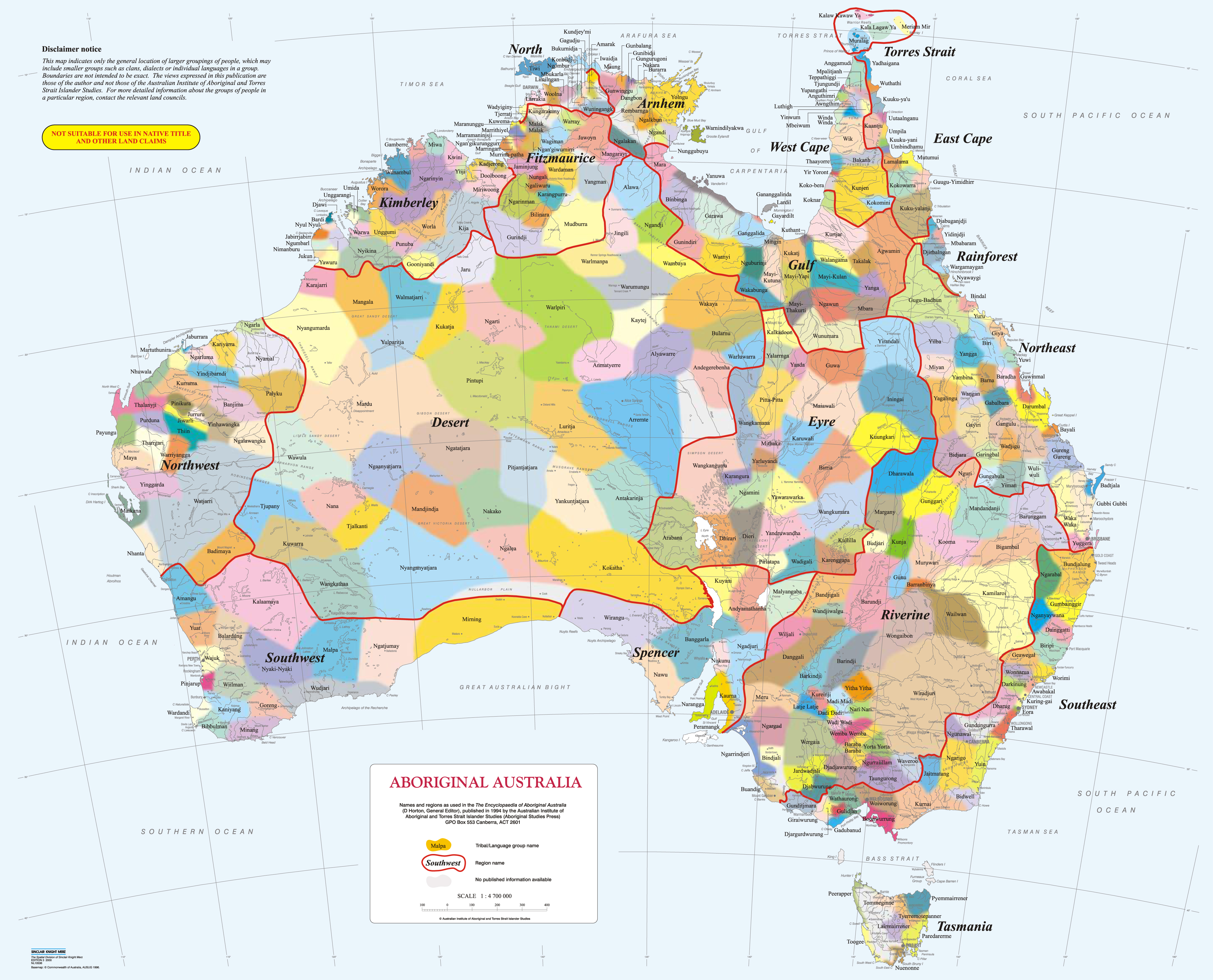
The main obstacle here is diversity. Aboriginal and Torres Strait Islander Cultures are extremely diverse. Even within each nation, there may be over 15 language groups with different protocols and practices. The reasoning behind this device / app / platform is to somehow bring this knowledge together to share. See the Aboriginal language groups within Australia https://mgnsw.org.au/wp-content/uploads/2019/01/map_col_highres.jpg
- Imagine when you’re entering Darkinjung country, and your iphone pings, and you are alerted to Country, significant sites, local stories and local foods etc.
Cultural protocols to consider:
- There are protocols around sacred sites. There are men’s sites, women’s sites and community sites. The men’s sites are exclusive to men, women’s to women etc. You have to be invited as only particular people can take you to these sites and you have to earn the right. https://www.aapant.org.au/sacred-sites/what-sacred-site
- Prior to entering a sacred site, you would have to undergo a cleansing
- Land councils (in NSW and NT) look after community sites, and they would put you in contact with a Culture and Heritage Officer who may be able to take you to these sites.
- Traditional owners should welcome you on to these sites, unless they are open to public (such as Bulgandry https://www.nationalparks.nsw.gov.au/things-to-do/aboriginal-sites/bulgandry-art-site-aboriginal-place )
- Contact Land Councils to engage with community / Elders to find traditional knowledge holders as they should be the ones contributing, not people who are off country.
- New South Wales Land Councils and boundaries http://alc.org.au/land-councils/lalc-boundaries--contact-details.aspx
2) DATABASE WITH INFORMATION ABOUT - BUSH MEDICINE, BUSH TUKKA, PLANT LIFE, TRADITIONAL CUSTOMS
- Team Name: Wollotuka Students
- Community: Awabakal (Newcastle NSW)
- Location: Newcastle University (NSW), Australia
- Challenge: Database with information about Bush medicine, Bush Tukka, Plant Life, animals, weather and Traditional Custodians
- Challenge Description: App that contains information about traditional custodians of the land. Bush medicine, traditional uses of the land, plants and animals, weather, dreaming and plant life to all be included to make a survival kit when your visiting country.The app is educational that will store and teach the traditional and cultural knowledge of country you are visiting.
- Background: The problems are that people are unaware about how to survive on country and how to care for country. This e-resource/app will be a database that maps country of Australian Indigenous culture. The benefits will be to educate others and promote sustainability of the land. Through GEO input we want to monitor quality of land, causes and affects people of the land.
- Recommended specifications: Lots of nations within Australia. May need to start small as space would be big.
- Resources: Nurakai committee
Space observation link: https://land.copernicus.eu/
NB: Aunty Bronwyn Chambers has provided the following information, but does not speak on behalf of all Aboriginal and Torres Strait Islander people. She only gives information that she has been taught, and that she knows.
The main obstacle here is diversity. Aboriginal and Torres Strait Islander Cultures are extremely diverse. Even within each nation, there may be over 15 language groups with different protocols and practices. The reasoning behind this device / app / platform is to somehow bring this knowledge together to share. See the Aboriginal language groups within Australia https://mgnsw.org.au/wp-content/uploads/2019/01/map_col_highres.jpg
- Imagine when you’re entering Darkinjung country, and your iphone pings, and you are alerted to Country, significant sites, local stories and local foods etc.
Cultural protocols to consider:
- There are protocols around sacred sites. There are men’s sites, women’s sites and community sites. The men’s sites are exclusive to men, women’s to women etc. You have to be invited as only particular people can take you to these sites and you have to earn the right. https://www.aapant.org.au/sacred-sites/what-sacred-site
- Prior to entering a sacred site, you would have to undergo a cleansing
- Land councils (in NSW and NT) look after community sites, and they would put you in contact with a Culture and Heritage Officer who may be able to take you to these sites.
- Traditional owners should welcome you on to these sites, unless they are open to public (such as Bulgandry https://www.nationalparks.nsw.gov.au/things-to-do/aboriginal-sites/bulgandry-art-site-aboriginal-place )
- Contact Land Councils to engage with community / Elders to find traditional knowledge holders as they should be the ones contributing, not people who are off country.
- New South Wales Land Councils and boundaries http://alc.org.au/land-councils/lalc-boundaries--contact-details.aspx
3) MAKING CULTURAL INFORMATION ACCESSIBLE ROUND AUSTRALIA (VOICES, TRUTHS, CULTURES, SITES)
- Team Name: Michael, Tammy, Sally, Rhyann
- Community: Newcastle, Awabakal
- Location: Newcastle University (NSW), Australia
- Challenge: Making cultural information accessible around Australia.Including voices, truths, cultures and sites.
- Challenge Description: When people travel around, they are not aware of the diversity of First Nations people, clans (groups), facts, languages and heritage sites.Part of educating people about richness of Indigenous heritage could be making this information available.How good would it be if it could include Indigenous voices? Stories? Could geographically based data help people understand the diversity in Australian Aboriginal culture, and by extension all First Nations?
- Background: Anyone visiting Country should have the opportunity to connect with the local cultures and stories. A problem is getting the information and making it accessible.
- Recommended specifications: Time is an issue with stories, and where cultural knowledge is only held by aging Elders.
- Resources: There is an existing massacre database and maps of Nations etc. LALCS and Elders would have a lot of information.
NB: Aunty Bronwyn Chambers has provided the following information, but does not speak on behalf of all Aboriginal and Torres Strait Islander people. She only gives information that she has been taught, and that she knows.
The main obstacle here is diversity. Aboriginal and Torres Strait Islander Cultures are extremely diverse. Even within each nation, there may be over 15 language groups with different protocols and practices. The reasoning behind this device / app / platform is to somehow bring this knowledge together to share. See the Aboriginal language groups within Australia https://mgnsw.org.au/wp-content/uploads/2019/01/map_col_highres.jpg
- Imagine when you’re entering Darkinjung country, and your iphone pings, and you are alerted to Country, significant sites, local stories and local foods etc.
Cultural protocols to consider:
- There are protocols around sacred sites. There are men’s sites, women’s sites and community sites. The men’s sites are exclusive to men, women’s to women etc. You have to be invited as only particular people can take you to these sites and you have to earn the right. https://www.aapant.org.au/sacred-sites/what-sacred-site
- Prior to entering a sacred site, you would have to undergo a cleansing
- Land councils (in NSW and NT) look after community sites, and they would put you in contact with a Culture and Heritage Officer who may be able to take you to these sites.
- Traditional owners should welcome you on to these sites, unless they are open to public (such as Bulgandry https://www.nationalparks.nsw.gov.au/things-to-do/aboriginal-sites/bulgandry-art-site-aboriginal-place )
- Contact Land Councils to engage with community / Elders to find traditional knowledge holders as they should be the ones contributing, not people who are off country.
- New South Wales Land Councils and boundaries http://alc.org.au/land-councils/lalc-boundaries--contact-details.aspx
4) MAPPING COASTAL EROSION OVER TIME
- Team Name: Michael, Tammy, Sally, Rhyann
- Community: Newcastle, Awabakal
- Location: Newcastle University (NSW), Australia
- Challenge: Mapping coastal erosion over time
- Challenge Description: How to preserve land, heritage and identity. How ca we map coastal erosion and prevent issue from devastating areas.
- Background: Various problems: Losing land and country due to coastal erosion. People/animals use all coastal users. Tourism – particularly Newcastle. Losing Indigenous culture and heritage
- Recommended specifications: Time (longitudinal). Technology
- Resources:
Specific examples of coastal erosion (eg Stockton)
Space Observation links:
https://www.coastal-tep.eu/portal/
NB: Aunty Bronwyn Chambers has provided the following information, but does not speak on behalf of all Aboriginal and Torres Strait Islander people. She only gives information that she has been taught, and that she knows:
Coastal erosion big issue for the East Coast
Stockton
- https://www.newcastleherald.com.au/story/2201123/dangerous-erosion-on-stockton-beach/
- https://www.newcastleherald.com.au/story/5694117/why-is-stockton-beach-washing-away-and-what-can-we-do-to-stop-it/
Norah Head
Wamberal
5) TALKING TO COUNTRY
- Team Name: Gi uyi yarri (Walk and Talk)
- Community: Awabakal (Wollotuka Institute) (Newcastle NSW)
- Location: Newcastle University (NSW), Australia
- Challenge: Talking to Country. Michael Anderson spoke about the star stories.
- Challenge Description: An app that encourages connection to “country” of all people by telling stories about the stars in language, Water stories. Mapping country. Recording sacred sites before they are lost. Benefits of country on health and wellbeing. Night part of App – tells “star stories” in language or helps you find elders who can tell these stories. Day part of App where people can take photos of country and express their connection to the country. Records of important river systems that are being lost.
- Background: We want to excite all people to get excited by our stories, our experiences with country. We are losing records of sacred sites. Getting Indigenous people healthy by connecting back to country. We are losing river systems and stories associated with the water.
- Recommended specifications: Getting mobs (community) together. Finding people to tell stories. Developing agreements with mobs.
- Resources:
Dr Raymond Kelly elder at Wollotuka Institute at the University of Newcastle.
NB: Aunty Bronwyn Chambers has provided the following information, but does not speak on behalf of all Aboriginal and Torres Strait Islander people. She only gives information that she has been taught, and that she knows.
- The main obstacle here is diversity. Aboriginal and Torres Strait Islander Cultures are extremely diverse. Even within each nation, there may be over 15 language groups with different protocols and practices. The reasoning behind this device / app / platform is to some how bring this knowledge together to share. See the Aboriginal language groups within Australia https://mgnsw.org.au/wp-content/uploads/2019/01/map_col_highres.jpg
- Imagine when you’re entering Darkinjung country, and your iphone pings, and you are alerted to Country, significant sites, local stories and local foods etc.
Cultural protocols to consider:
- There are protocols around sacred sites. There are men’s sites, women’s sites and community sites. The men’s sites are exclusive to men, women’s to women etc. You have to be invited as only particular people can take you to these sites and you have to earn the right. https://www.aapant.org.au/sacred-sites/what-sacred-site
- Prior to entering a sacred site, you would have to undergo a cleansing
- Land councils (in NSW and NT) look after community sites, and they would put you in contact with a Culture and Heritage Officer who may be able to take you to these sites.
- Traditional owners should welcome you on to these sites, unless they are open to public (such as Bulgandry https://www.nationalparks.nsw.gov.au/things-to-do/aboriginal-sites/bulgandry-art-site-aboriginal-place )
- Contact Land Councils to engage with community / Elders to find traditional knowledge holders as they should be the ones contributing, not people who are off country.
- New South Wales Land Councils and boundaries http://alc.org.au/land-councils/lalc-boundaries--contact-details.aspx
6) DETECTING GROUND WATER POINT BORE WELLS
- Team Name: GAGAN
- Community: Farmar
- Location: Thailand
- Challenge: Detecting temperature, humidity and soil moisture by arranging mini weather station in field.
- Challenge Description: For farming water plays a major role. In irrigation bore wells are really important, for installing bore wells we need to find out the exact ground water points. Usually farmers need experts in the field and various rough points to install the bore well. But, when we use the satellite image data to find out the exact points of ground water, there’s no need of experts and rough points, which will lead to effective cost cutting. On the other hand, when we install the mini weather station, we easily detect the temperature, humidity, soil moisture, and pm values. Detecting all these values in advance will help you to use the water effectively. Determining the pm values can help in crop density. If pm 2.5 value increases crop density will be decreases. This will lead to unhealthy crop and the ineffective production of crop.
- Background: Main problems we considering are ground water. Intensive use of groundwater for irrigation leads to the lowering of water tables, reducing its potential for future use. It also generates multiple negative externalities, including salinity, stream depletion, or land subsidence that directly affect agricultural productivity, water users and the environment. So, what we are doing was detecting precise ground water points for installing bore wells. This leads to precision agriculture and also it helps in not wasting resources. On the other hand, we are arranging a mini weather station which helps in detecting Temperature, humidity, soil moisture and pm values in advance. This will help in effective use of water and pm values will help in detecting the density in crop. Main users for our project are farmers and our project will help farmers. By solving these issues, we can create huge impact on agriculture development in future, because these issues lead the farmer contact directly with producer without any expert interference in the fields.
- Recommended specifications: The main technological issues facing while solving these problems are ground water detection, which was main concern and also soil moisture for required area. Data availability of required area because not every satellite can produce the ground water data.
- Resources:
Bhuvan satellite web portal
https://bhuvan.nrsc.gov.in/bhuvan_links.php#
Grace satellite portal
https://earthdata.nasa.gov/learn/sensing-our-planet/getting-at-groundwater-with-gravity
7) PREVENTION OF CROP FAILURE AND ECONOMIC LOSS DUE TO WATER CRISIS AND DROUGHT
- Team Name: Geo4H20
- Community: Asian Institute of Technology
- Location: Pathumthani, Thailand
- Challenge: Prevention of crop failure and economic loss due to water crisis and drought.
- Challenge Description: Water crisis is on rise in Thailand. Situation is critical with eight provinces, now listed as critical. The expansion of local water bodies in drought-hit provinces is causing a major problem. Three major catchment runs less than 10 % of full capacity as well as Mekong river is running too low to catch any fish, which has hampered public consumption as well. But more importantly, the long period of drought each year has led to a decrease in amount of water flowing into dams. These adversely affect the production of crops in agricultural land which require water continuously over the crop cycle or crop period. One of the important crop is Rice in Thailand. Thailand is also one of the major exporter of rice in world. But due to the water crisis many fields have been abandoned recently. So, this is a current challenge: how to provide better management practice for agricultural land and farmers keeping in mind the current water crisis by using earth observation data.
- Background: Water crisis has been a severe problem around the world, because of unprecedented population growth and unsustainable water management practice. Along with clean and safe drinking water, agriculture is one of the sector affected by water crisis. It is becoming a global issue, especially in agriculture. In the context of Thailand, drought has seriously impacted the agricultural crops and yield, which has led to declination of living standard of farmers. Agriculture is not moving forward with the recent technology. Still traditional agricultural practices and management are implemented, causing reduced yield, early crop damage, crop abandon, economic loss etc. Anthropogenic activities and climate change are seriously hindering those agricultural practices. There is a need for a platform that can adopt different scenarios (drought, crop stress, etc.) to improve agricultural practices and management. The developed platform will be primarily focused for farmers, however the platform will integrate different government and non-government organization associated with meteorology, irrigation, agriculture, land development, as well as research institutes. The agriculture insurance sector can also benefit. Farmers will be able to know the current status of their crops as well as they can get notification regarding what needs to be done further. Farmers will also be advised to switch the crop if the drought condition is likely to occur.
- Recommended specifications: a) Coarse resolution datasets b)Diverse scale of datasets c) Longer processing time for large extent
- Resources:
8) END-TO-END SOLUTIONS FOR FARM MANAGEMENT
- Team Name: HandyFarm
- Community: Philippines
- Location: Melton Bender, Asian Institute of Technology
- Challenge: Develop a mobile application system to assist local farmers in addressing issues on low agricultural productivity by providing end-to-end solutions on farm management (planting to marketing).
- Challenge Description: A mobile application system that provides end-to-end solutions to the local farmers in farm management such as crop health monitoring, soil analysis, soil crop suitability analysis, yield estimation, advisory services on correct timing on planting, applying fertilizer, and harvesting schedule of crops. It targets the local farmers, government, and business sectors in the Philippines. The government can access the available crops produce and promote the crop produce to the business sectors. The newness of this application, from the existing farm management application, is that: 1) it provides other crops suitable for their farm for crop rotation and intercropping agriculture, and 2) it provides service on marketing where both farmers can sell their products while the costumers can input or recommend their demands and order through the application. The application will utilize earth observation satellite data such as Landsat, Sentinel, TRMM, Global Moisture, drought index, and will be integrated with in-situ data for improved analysis and validation.
- Background: The low agricultural productivity is one of the main problems in the Philippines. Technical reports indicate that this problem by the following:
- Further, low productivity greatly affects the farmers, employment, economy, and the population at large in general as well. Agriculture is one source of employment. In the Philippines for example, despite low contribution (~10%) of agricultural sector to the country’s GDP (2018), it still provides employment to the 30% of its total labor force. In other words, labor in agriculture is relatively low than any other services such as industries thus, majority of agricultural workers live below poverty line. Moreover, agriculture is essential as the foundation of food security especially on the rapid population growth situation that the world is experiencing; that further increases food demand and therefore affect the population in general.
- High transportation cost
- Crop diseases, climate change, natural hazards
- Expensive pesticides, fertilizers, and farm machineries
- Rapid conversion of agricultural lands to other land uses due to urbanization and industrialization
- Lack of government support, education, moral boost
- Lack of market information system and low-price of products (because of middlemen).
- Limited knowledge and information on temperature data, and rainfall occurrence
- Recommended specifications:
- Poor internet connection
- Low image resolution (from camera and climate data)
- Resources:
9) FLOOD HAZARD PLATFORM
- Team Name: Power-O
- Community: RSGIS, SET
- Location: Asian Institute of Technology, Thailand
- Challenge : To create monitoring and responding platform during flood hazard.
- Challenge Description: When flood hazard occurs, people who are affected will be desperate to gain information such as where are the flood areas, risk areas and safe areas. To generate these kinds of information, various EO data from different sources are needed for the experts to analyze and turn them into straightforward information that are ready to be published. Similarly, to help the flood response team to understand the actual situation and create a relevant responding plan, crowdsourcing SOS data from flood victims is needed. This is where we come up with an idea to create a web application that works as an intermediate where experts/ response team and flood victims can communicate and work together to get through the hazard.
- Background: In Thailand, flood hazard generates the highest impact to economic and people’s lives throughout the years. Moreover, under the climate change, flood patterns can be changed and become more unpredictable. Whenever the hazard has taken place, people affected don’t have an easy to access platform to get information about the hazard and report their situation. Luckily, we can use web application to solve these problems. Developer and users for the application:
- Expert: People who gather EO data and perform an analysis. Then generate flood map, risk map, summary and published them via the application.
- Response team: People who gather SOS data sent from flood victims, notification from sensors, use risk map and make a decision to search, rescue and evacuate the victims.
- Flood victims: People who obtain information about the hazard and send SOS via the application.
- Recommended specifications : Limited number of sensors in the remote areas. Hard to generate accurate real-time flood map. Some EO data has relatively low temporal resolution, this effect the release frequency of risk map. People who live in remote areas don’t have access to internet, they cannot send geo-tagged images to show how severe their situation is.
- Resources
- EO data from GEE
- Sensors data (flood monitoring sensor)
- Geo-tagged images (crowdsourcing data from flood victims)
10) HEALTH INFORMATION MONITORING SYSTEM
- Team Name: SDG ACCELERATOR
- Community: Rural arears affected by malnourishment
- Location: India
- Challenge: Health Information Monitoring System that helps in monitoring diseases and health conditions (communicable and non-communicable), primarily focusing on child malnutrition. A real-time data collection and monitoring of child nutrition outcomes using a crowd sourcing platform.
- Challenge Description: Currently, majority of frontline health workers supporting community-based management of acute malnutrition programs are trained in standard protocols but do not have frequent on-site support, supervision or job aides. Paper-based systems are subject to error and misreporting; thus, a real-time data collection and monitoring system is muchly needed. However, the success of a community-based malnutrition program is limited by a number of factors, including lack of adherence to treatment protocols and inaccurate record keeping due to the lack of training, insufficient supervision and absence of up-to-date information. There are limitations in the paper-based system for data collection and management. The significant challenge includes missing information, recording making data of poor quality that is not accessible to the decision makers within a reasonable timeframe. Lack of timely information has made programs unable to respond to address immediate needs including the upsurge in acute malnourished children. Easy to use job aids and effective performance monitoring systems are needed to improve the CMAM globally. SOLUTION: Real-time collection and monitoring of data is an innovative way in improving data collection and health care support services through a location-based system. It enables the field worker to obtain data using a mobile device with geo-tag that can be used to easily identify the vulnerable groups. These data can be visualized easily with maps which can be used in formulating policy or policy improvement based on the needs.
In addition, this system of data collection can collect several socio-economic information that can be stored in a system. Community information system is important to measure changes in the nutrition status of vulnerable people, namely children and women, they track progress in the implementation of actions, and they help to prioritize response. Understanding the extent, location and determinants of malnutrition is vital to be able to mount appropriate responses and to inform the allocation of finite resources.
A range of data related to the immediate and underlying causes of malnutrition are therefore needed to be able to analyze determinants, target vulnerable groups and prioritizes effective interventions. Information on the coverage of services and programs, and stakeholder mapping also helps to identify appropriate responses. Specifically, this system is an effective way to addressing malnutrition through a real-time data collection and monitoring of child nutrition outcomes using a crowd sourcing platform. The developed application will collect the anthropometric data of a child to understand the nutritional outcome. In addition, it will be easier to find and identify the factors influencing malnutrition because the application can be used to collect other data such as household information and demographic profile. The data collected can then be used in building a community health information system that can be used for intervention and development based on the specific needs. It will enable to employment of timely interventions wherever and whenever required and the prioritization and direction of the interventions needed to improve the nutritional status in specific geographical areas.
- Background: Malnutrition is the world’s most serious health problem, and the single largest contributor to child mortality and the global burden of disease. There are at least 15 million children suffering from acute malnutrition worldwide. Approximately 17 million children are suffering from severe acute malnutrition (SAM). When compared to well-nourished children, those suffering from SAM are nine times more likely to die and face an increased risk of morbidity through a weakened immune system. Community-based management of acute malnutrition is proven high-impact, cost-effect approach in the treatment of acute malnutrition in developing countries, in which the majority of cases are treated at community level. It enables the community health workers and volunteers to identify and initiate treatment for children before they reach serious illness, using ready to use therapeutic diets that are is a high in energy, enhanced-based micronutrient and include routine medications that the mother can give to their children at home.
- Recommended specifications
- The mobile application is developed for the Android platform.
- Willingness of the people to share their demographic information with the social workers.
- Resources (any links you would like to share with the hackers that might help them to understand your challenge better)
- https://www.unicef.org/press-releases/2018-global-nutrition-report-reveals-malnutrition-unacceptably-high-and-affects?fbclid=IwAR02cvHdEnNL8zJF9STiS_4OwOg8f9Th-rAWiTc8GNJ8uZyQB2z7E-td9IE
- https://en.wikipedia.org/wiki/Malnutrition_in_India
11) EO FOR FOOD SECURITY IN REMOTE, RURAL COMMUNITIES OF SOUTHEAST, ALASKA
- Team Name: Southeast Alaska GeoHackathon
- Community: University of Alaska Southeast, Juneau, Alaska
- Location: Juneau, Alaska, United States
- Challenge: The team came up with two “resource challenge” case studies -- harmful algal blooms (HABs) and uncertainty about salmon runs -- that both affect food security in remote, rural communities of Southeast Alaska, and were equally interesting leads for weaving together a solution incorporating citizen-science input, mobile applications, ‘in situ’ and satellite-based earth observation technology, and networks of scientific experts.
- Challenge Description: The Southeast Alaska team felt there were a few elements that would be important for any EO-based solutions to address challenges of HABs and salmon-run uncertainty. Specifically:
- Visualization of EO conditions on a mobile platform itself could a form of valuable outreach and could be an appealing way to draw locals in.
- EO data could be useful for locals to understand how circumstantial/abnormal current conditions are relevant to historical conditions, as well as compared to other areas, e.g., the 'global weirding index'.
- If locals could contribute their observations to EO platforms - and these contributions were visible - EO data would have greater value, relevance, and validity to local communities.
- Social networks could possibly be integrated into a type of EO observation network across fragmented areas of southeastern Alaska.
Framework for an EO Solution
The team came up with a conceptual framework to think about how to integrate EO and elements above - such as local observations - to address both the PSP/Salmon case studies. The framework involves: A) in situ and satellite EO data; B) an app to visualize environmental condition from EO data; C) local users that actively contribute, and see their, observations, as well as more passive users that contribute opportunistically or through existing social networks; and D) a scientific network that not only generates EO visualizations but also generates measures of abnormality in a meaningful way (the "weirdness index") and is a source of expertise to provide specific feedback to locals.
- Background: Southeastern Alaska is a biologically rich, temperate zone with a steep gradient across icefields, rainforest, freshwater and marine environments. Environmental change in southeast Alaska is less certain and uniform than that found in the permafrost and sea-ice conditions of the Arctic zone that represents the majority of Alaska. Locals certainly observe changes, but how circumstantial are these changes? So, addressing this uncertainty, with local input, seems paramount for EO to help address resource challenges in this region.
Alaska Native elders from 2 southeast Alaska communities - Yakutat and Sitka - discussed numerous changes from historical conditions across a range of environments -- marine, freshwater & terrestrial. Two resulting case studies appealed to the team, are linked in that they address aspects of food security, and appeared to have strong relevance to EO:
- Uncertainty about Salmon Runs. The Situk River in Yakutat Alaska is a comparably small stream in Alaska but among the most productive: the upper freshwater environs hosts the largest Steelhead population and all five species of anadromous (sea-run) salmon, accounting for almost 1/3rd of all angling in the region, and its lower estuarine reaches have been very important for traditional subsistence fishing for centuries. But, in the last decade, salmon runs for some species and in some years have unpredictably dropped to 10 percent of the historical average, with local fisheries entirely closing and the traditional subsistence fishery season shrinking by nearly 2/3rds. The issue has been compounded by climate related issues such as shifts in run timing, drought conditions that impair the ability of salmon to reach upper streams to spawn, and noticeable declines in fish growth. Alaska Native panelists voiced concern about the fate of the fishery, and its impacts on traditional practices and rural livelihoods. Some information about stream conditions is available through a fish weir and a stream gauge. But is it possible EO technology, such as localized climate forecasts, including drought and river levels, off shore and more nearshore in-situ remote sensing data, and a better network of stream and fish distribution data could be fed to local users and agency managers to mitigate the uncertainty about salmon run timing and productivity?
- Paralytic Shellfish Poisoning. Harmful algal blooms (HABs), a phenomena in which small components of the marine phytoplankton community (particular forms of dinoflagellates spp.) expand rapidly, spread into marine food webs, and expose humans to toxins through the consumption of contaminated fish or shellfish, or by contacting contaminated water. Although HABs are hard to predict, it is generally accepted that HABs are increasing in frequency, intensity, and duration on a global scale and some of this may be due to changes relating to climate, such as ocean acidification and warming. Alaska Native panelists expressed concern about threats to shellfish foods, which have been collected traditionally in intertidal areas throughout the region. Lab based testing of shellfish or water samples have traditionally been used to evaluate toxicity. But is it possible EO technology, such as remote sensing from satellites and a network of in situ 'water samplers' could be used, along with local input, to track algal blooms before people get exposed?
- Recommended specifications: Challenges Relating to EO:
Although the two resource issues above appear to be distinct, the team discussed several EO-related challenges in common to both, including:
- Underlying issues may be complex and involve understanding change / EO data across different environments -- e.g. ocean warming vs drought conditions in streams.
- Although locals are experiencing abnormal environmental phenomena or trends, locals are very uncertain about the degree to which these conditions are abnormal, and how prevalent these are in other places.
- EO Information/data may not be of sufficient resolution to understand conditions at the local scale of Alaska communities.
- EO data / information are generally not in an accessible format/medium to locals.
- Telecommunications in southeast Alaska's rural/fragmented communities are poor or inconsistent, even locally.
- Locals are unlikely to depend on EO technology or models to make local decisions per se.
Possible EO Information Needs?
- PSP - In situ and satellite EO data on HABs; in situ water sampling in marine environments; remote identification of toxic forms of phytoplankton; the ability for locals to remotely test water samples and send observations to scientific experts; ...
- Salmon - offshore marine EO data; in situ estuary conditions and fish sampling; real-time fish weir data; real-time stream conditions (discharge / water temperature / dissolved oxygen, etc.); stream level forecasts; drought indices; ...
- Resources:
Southeast Alaska Tribal Toxins (SEATT) partnership to combat the risks of HABs:
- https://toolkit.climate.gov/case-studies/alaskan-tribes-join-together-assess-harmful-algal-blooms
- Southeast Alaska Tribal Ocean Research http://www.seator.org/
- USGS hydrological gauges https://waterdata.usgs.gov/ak/nwis/rt
- Alaska Ocean Observing System https://aoos.org/
- Alaska Anadromous Fish Waters Catalog https://www.adfg.alaska.gov/sf/SARR/AWC/
- Alaska Fish Weir & Count Data https://www.adfg.alaska.gov/sf/FishCounts/
12) IMPROVING ACCESS TO LAND OBSERVATION DATA IN INDIGENOUS COMMUNITIES FOR GREATER AND BETTER TERRITORIAL ACTION
- Team Name : CIPTO - Centro de Información y Planificación Territorial Indígena de los Pueblos Indígenas del Oriente
- Community : 16 Indigenous Peoples of the Loreto region, 488 communities and 28 Indigenous Federations.
- Location: Región Loreto - Perú.
- Challenge: Can we improve access to land observation data in indigenous communities for greater and better territorial action through android operating systems?
- Challenge Description: Currently, despite efforts to democratize access to land observation data and satellite images and to popularize technologies, this information is still concentrated in centers with technology, electricity and the Internet. The digital divide still remains large in indigenous territories and also access to satellite data. Smartphone technology is present in the Amazon and among Indigenous Peoples. The easy use of the equipment and intuitive applications make smartphone technology attractive to all rural sectors. National statistics indicate that it is more likely that an indigenous community member is able to purchase a phone than a computer, and it is much more likely that its a smartphone with an Android operating system. This reality offers the opportunity to generate an information channel from the earth observation data to the indigenous communities, because the Android operating system allows viewing and managing earth observation satellite data in a simple, tactile way and without depending on an internet connection, provided that these are available in the appropriate extensions (as is the case with SQLite data geobases). High resolution and free-use satellite images available on the internet can be transformed into SQLite formats through free software, unfortunately the available images are old and are not suitable for Indigenous Peoples to respond to changes in the Amazonian forests. Improving the capacity and opportunity for indigenous peoples to respond to priority ecosystems and mega-diverse ecosystems such as the Amazon, with land observation information is relevant for the protection of the forest ecosystem services and to promote actions to mitigate climate change.
An example occurs in the Peruvian Amazon, where more than a hundred indigenous men and women manage satellite images in SQLite format through apps that are freely available and use early deforestation alerts on their smartphones to guide themselves towards deforestation drivers such as illegal mining, illegal logging, land invasions, illicit crops. They have reported and denounced the unauthorized changes in the use of the forest with the official authorities. Indigenous communities have turned information into action, thus they have been able to curb illegal acts of deforestation and degradation in their territories and protect their forests. However, the transformation of satellite images and early deforestation alerts into formats that are read and managed by smartphones requires multiple steps and professionals to apply them. So, can we transform satellite images and earth observation data into formats supported by android technology? Is it possible to create an automated procedure to transform sentinel images into sqlite or other versions supported on smartphones? Is there a way to automate through a free app, platform or software the transformation of the earth observation data to be visualized and managed from cell phones with android operating systems?
- Background: Land observation data has proven to be an effective information tool for changes in the forest, such as loss of forest cover, changes in land use and early warnings of deforestation. A recent study by Columbia University has measured the impact of technology on Amazonian forests in Peru, determining that indigenous peoples with access to satellite information and technology have reduced deforestation in their titled territories. Indigenous Peoples, owners of vast hectares of forests in the Amazon and other forest users could use this information to take territorial, legal or media impact actions on unauthorized changes in their forests; however, access to the earth observation data is almost nil. Satellite data is important for Indigenous Peoples with forests because it allows them to identify changes in their titled territories and in neighboring forests of importance, early deforestation alerts will allow them to prioritize control and surveillance sites, validate with field information main drivers of deforestation or recovery of forest cover, also visualize the tracks or routes of deforestation. Finally the set of images of observation of the land allow activating the historical and cultural memory of the people, determining the influence of policies on indigenous lands and thereby strengthening governance. The modalities of access to satellite data have been mostly through physical maps because the digital divide remains high mainly in native or indigenous communities. The costs of moving the data in physical are high because the Amazon is a very large, isolated and sometimes inaccessible territory. In addition, access to electricity and internet is limited to Amazonian cities and very low in native communities. Android technology has come hand in hand with the smartphones to indigenous communities, opening an opportunity for access, visualization, management, validation and feedback of earth observation data from satellites without internet connection dependence. At present, The Information and Territorial Planning Center of the Organization of Indigenous Peoples of the East - CIPTO - distributes on demand from the indigenous communities of five indigenous peoples of the Amazon of the Loreto Region, satellite information in android format for use in actions to control and mitigate the loss of forest cover, but it depends on professionals who can apply a sequence of steps in various computer software and geographic information systems for the transformation of information. CIPTO proposes to the GEOHACK Challenge the automation of procedures for transforming sentinel images for viewing and management through smartphones. The automation of procedures will allow indigenous peoples to access satellite information more easily and in a timely manner through their smartphones, reducing the cost of access by reducing the dependence on professionals responsible for the transformation of satellite information.
- Recommended specifications: The solutions must allow transfer of satellite images and / or earth observation data in formats that are possible to visualize and manage by Android operating systems. The solutions must allow the information to be stored in the equipment to be managed in off-line modes or without internet connectivity and must be developed with free software.
- Resources:
