A central part of GEO’s Mission is to build the Global Earth Observation System of Systems (GEOSS). GEOSS is a set of coordinated, independent Earth observation, information and processing systems that interact and provide access to diverse information for a broad range of users in both public and private sectors. GEOSS links these systems to strengthen the monitoring of the state of the Earth. It facilitates the sharing of environmental data and information collected from the large array of observing systems contributed by countries and organizations within GEO. Further, GEOSS ensures that these data are accessible, of identified quality and provenance, and interoperable to support the development of tools and the delivery of information services. Thus, GEOSS increases our understanding of Earth processes and enhances predictive capabilities that underpin sound decision-making: it provides access to data, information and knowledge to a wide variety of users.
This ‘system of systems’, through its GEOSS Platform (former GCI), proactively links together existing and planned observing systems around the world and support the need for the development of new systems where gaps currently exist. It will promote common technical standards so that data from the thousands of different instruments can be combined into coherent data sets.
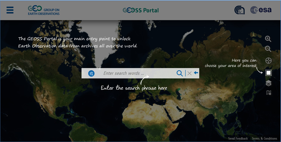
The ‘GEOSS Portal’ offers a single Internet access point for users seeking data, imagery and analytical software packages relevant to all parts of the globe. It connects users to existing data bases and portals and provides reliable, up-to-date and user friendly information – vital for the work of decision makers, planners and emergency managers.
For users with limited or no access to the Internet, similar information is available via the ‘GEONETCast’ network of telecommunication satellites.
The Global Earth Observation System of Systems’ Platform (former GEOSS Common Infrastructure, or GCI) proactively links existing and planned observing systems around the world and supports the development of new systems where there are gaps. The GEOSS Platform promotes the use of common technical standards so that data from thousands of different instruments can be combined into coherent data sets.
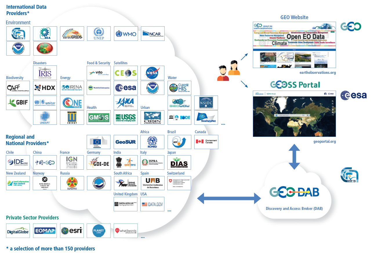
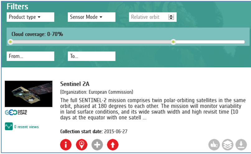
The GEOSS Portal offers a single Internet access point to Earth observation data, information and knowledge from all over the world for users with different backgrounds and from different disciplines. The Portal has an intuitive, easy-to-use interface to discover, access and use the ever-growing quantities of GEO resources. Through the Portal, the GEOSS Platform connects the users to the wealth of heterogeneous collections of databases and other portals and provides reliable, up-to-date and user friendly (current and historical) information – vital for the work of decision/policy makers, planners and emergency managers. Both the public and private sector but as well citizens are served.
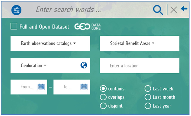
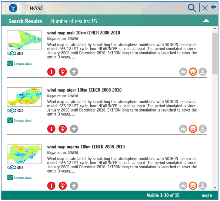
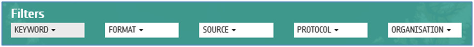
Users can discover data considering temporal, thematic and geographic search criteria, and apply progressive filtering to retrieve, quickly and accurately, the resources they need. Information regarding the data can be inspected either via an information window or visually on different background maps if enabled before download.
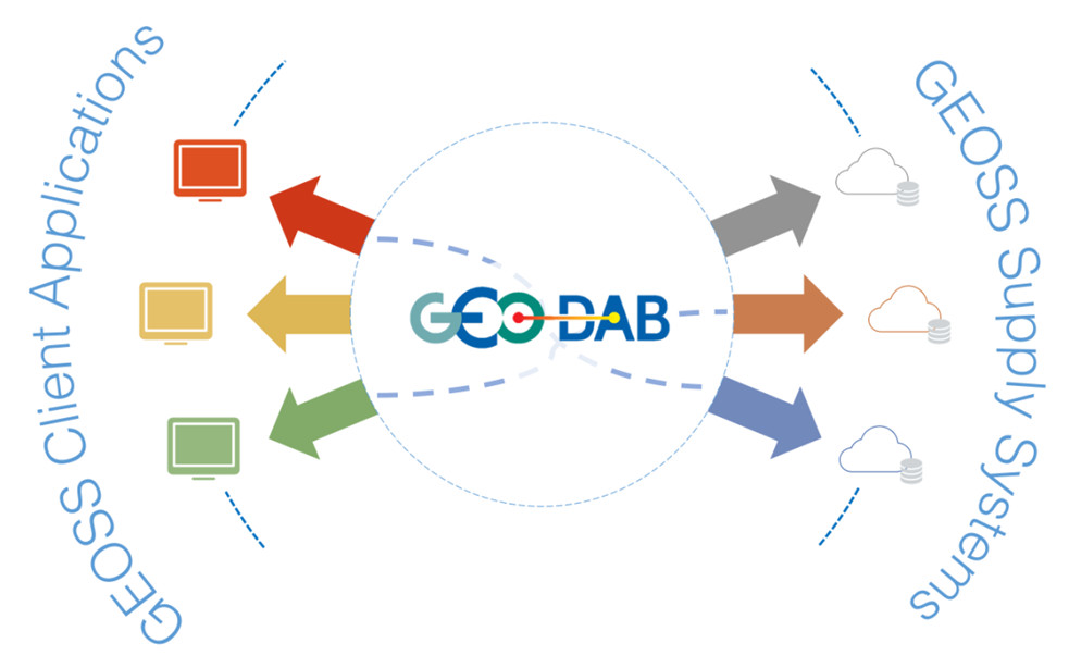
For users with limited or no access to the Internet, there are regions making similar information available via the satellite service, GEONETCast. The GEOSS Platform is a brokering infrastructure.
The GEO Discovery and Access Broker (GEO DAB) is the primary mechanism by which all data and information is discovered and accessed. The GEO DAB implements the necessary mediation and harmonization services through Application Program Interfaces (APIs). These APIs allow data providers to share resources without having to make major changes to their technology or standards.
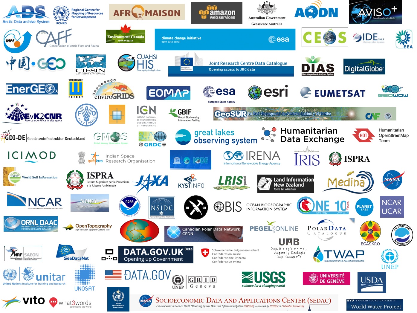
Presently GEOSS Platform brokers more than 150 autonomous data catalogs and information systems, useful for the different GEO Societal Benefit Areas including data from: CAFF, Data.gov, Data.uk, EEA, GBIF, Iris, JRC Open Data catalog, NASA, NCAR, NOAA, OCHA HDX, RCMRD, UNEP, UNOSAT, USGS, Web Energy Services, WMO WIS and many more.
Data providers are constantly being added and brokered, according to user needs, thematic and geographic balance of the data and relevance of resources shared.
For new data providers, see below the GCI Registration and Brokering Process
GEONETCast is a global network of sustained and cost-effective satellite-based dissemination systems. It delivers Earth observation (EO) data and products to and from GEO community activities, initiatives and flagships on a routine basis.
GEONETCast is a GEO foundational task and an integral part of the GEOSS Common Infrastructure (GCI). It facilitates access to data to support the GEO Societal Benefit Areas. It contributes to the implementation of GEOSS, as defined in the GEO 2016–2025 Strategic Plan.
GEONETCast is based on collaboration between China (CMA), EUMETSAT and the US (NOAA). Its architecture is open and can accommodate other partners.
Its operation is based on various regional broadcasting systems, with established routine data exchange between them. It relies on infrastructure put in place, and sustained, by meteorological agencies. This creates synergies and complementarities between GEO-related data and routine data delivered for operational meteorology.
GEONETCast currently serves approximately 6,000 users in 169 countries.
GEONETCast is made available to support GEO objectives. It focuses on providing support, in term of data access, to and from GEO Flagships, Initiatives and Community Activities, considering priorities for each region.
GEONETCast is also used for ad-hoc data transmission where high speed landlines and/or internet are not available, or in regions where terrestrial communication lines have been disrupted by disasters.
GEONETCast is able to disseminate high volume data worldwide, even to areas with limited access to the internet.
GEONETCast delivers a wide range of EO satellite data and products, generated by CMA, EUMETSAT, NOAA, and many third-party providers. The range of products covers applications relating to weather forecasting, atmospheric composition, marine meteorology, oceanography, and land management.
Building capacity is one of GEONETCast’s achievements. In addition to providing data access, GEONETCast, through its Training Channel, provides opportunities for users to further exploit the data they receive.
The Training Channel:
GEONETCast, through its Disaster Channel, is available to deliver products in support of the International Charter on Space and Major Disasters.
Discovering Data
Users wishing to explore the range of environmental data available through GEONETCast will find the full list of products in the Product Navigator and the GEO Web Portal.
Several regional centres are responsible for establishing the satellite-based regional dissemination system — based on Digital Video Broadcast (DVB) technology — and providing complementary services to a common user community.
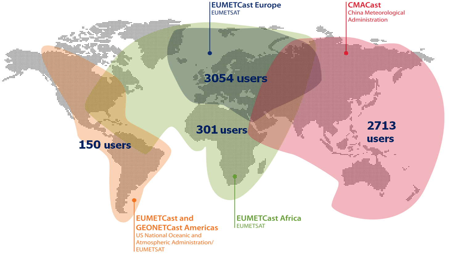
GEONETCast is currently available in Europe, Africa, the Americas and Asia-Pacific region.
EUMETCast is the EUMETSAT contribution to GEONETCast, with coverage over Europe and Africa and the Americas. Established in 2004, EUMETCast has more than 4,000 registered reception stations with more than 3,400 users benefiting from the environmental data it provides.
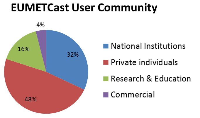
The EUMETCast user community is diverse ranging from operational meteorological forecasting centres to enthusiastic amateurs interested in remote sensing data. The large number of private individuals receiving EUMETCast is testimony to the ease with which a station can be set-up.
CMACast is the China Meteorological Administration’s contribution to GEONETCast, with coverage over the Asia-Pacific region. CMACast utilises the AsiaSat 4 satellite beam to broadcast data and products to more than 2,500 users. As well as serving the People’s Republic of China, CMACast is used in 20 countries in the Asia-Pacific region.
GEONETCast Americas is the Western Hemisphere component of GEONETCast, operated by NOAA. It provides data and products to more than 60 users in Central and South America and the Caribbean region.
For the users, GEONETCast is a user-friendly, and low-cost information dissemination service.
A typical GEONETCast reception station comprises a standard PC, a DVB reception device (internal or external), and a satellite off-set antenna fitted with a digital universal V/H LNB for Ku-band, or fitted with a circular polarisation feedhorn, bandpass filter and special LNB for C-band.
To decode and decrypt the EUMETCast data stream, EUMETCast Client Software and a EUMETCast Key Unit (EKU) are also required.
The cost of reception stations is kept to a minimum by using industry open standards as much as possible, resulting in an adaptable front-end solution to users' applications.
In addition to the front-end equipment, proprietary client software used to decode the DVB signal and data processing software will be required. These software applications are commercially available.
User registration steps are unique to each network provider. Users interested in receiving products and services delivered via GEONETCast should register with GEONETCast network provider covering their geographical location:
Feedback is welcomed, from:
Please use the GEONETCast Feedback Form (PDF, 47 KB).
Follow us on: