


China GEO supports Iran flood disaster response
News / 10 April 2019
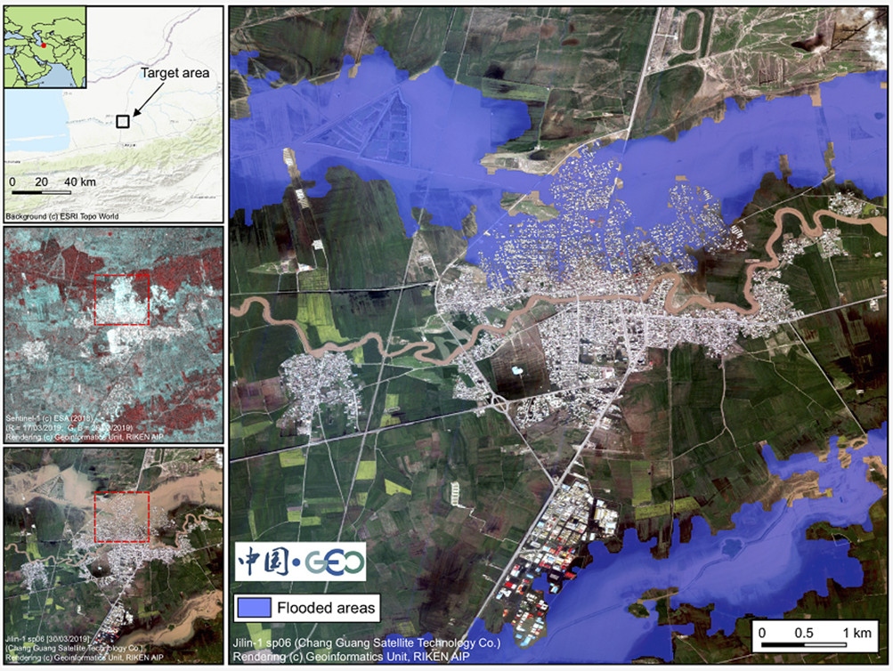
Record rainfall and flooding in Iran has led to substantial loss of life and forced evacuations of thousands of people since mid March 2019, causing hundreds of millions of dollars of damage. Responding to requests from UNESCAP and the Iranian Earthquake Engineering Association (IEEA), China GEO activated its Disaster Data Response (CDDR) Mechanism to provide high-resolution satellite imagery in support of disaster response planning.
Iran's Mehr News Agency has reported that 1,900 cities and villages have been flooded, while CNN reported that more than 140 rivers have burst their banks; 409 landslides have been reported; 78 roads have been blocked; and 84 bridges have been affected. Rapid access to high resolution satellite images is important for government agencies and first responders to assess damage, and prioritise and plan their response operations.
Established in 2016, the ChinaGEOSS Disaster Data Response Mechanism is responsible for coordinating the provision of Chinese high-resolution satellite data and disaster analysis products to disaster-affected countries. The mechanism has been successfully launched for earthquakes, floods, tsunamis and typhoons in thirteen countries.
Contributors include GEO’s regional initiative in Asia-Oceania (AO GEO), RADI, AIR, CRESDA, NSMC, CGSTL, SpaceWill, 21AT, LASAC, NSOAS, IGSNRR, CNIC and NAOC, Japan’s RIKEN Center for Advanced Intelligence Project, and the Committee on Data for Science and Technology (CODATA).
Following the activation of the CDDR for Iran, four contributors (CGSTL, CRESDA, LASAC and NSMC) developed satellite observation plans for flooded areas in Aq Qala, Darvazeh Quran and Pol Dokhtar, and have provided high-resolution Jilin-1 sp06 satellite images (0.92 meter) to support disaster response.
Prof. Keran Wang of UNESCAP confirmed that the data has been provided to Iran's National Disaster Management Organization (NDMO) and Iranian Red Crescent as the key disaster management operational bodies.
According to IEEA President Prof. Mohsen Ghafory-Ashtiany, the data is being used for flood analysis in cooperation with UN-HABITAT and the Saman Paydar Insurance Risk Management Institute (SPRMI).
ChinaGEOSS welcomes additional contributions of monitoring data and disaster loss information products: ftp://Iran-user:ChinaGEOSS2019@128.14.159.114
———
Ongoing support for disaster response
The Group on Earth Observations (GEO) supports disaster resilience by increasing coordination of Earth observations to improve disaster forecasting, mitigation, management and recovery, in line with the Sendai Framework for Disaster Risk Reduction.
A substantial reduction in loss of life and property can be achieved by strengthening cooperation and data sharing to help manage risks posed by fires, floods, earthquakes and other hazards.
———
For more information please contact secretariat@geosec.org.
Follow us on:


