


Blog / Diana Mastracci / April 15, 2020
Mario Vargas (Shakaim) is an Indigenous Shuar from the Ecuadorian Amazon who has been defending nature since he was a young boy. He has been the leader and technician of the Shuar Federation of Pastaza, supporting the formulation of a community broadcaster that disseminates information on the rights of the people.
Mario is a founding member of the GEO Indigenous Alliance that was established at GEO Week 2019 in Canberra, Australia to foster a continued, effective, respectful, and reciprocal relationship with GEO and representatives of indigenous communities from around the world. He is a member of the Network of Climate Finance Specialists, as a representative of South America, and currently works at The Coordinator of the Indigenous Organizations of the Amazon Basin (COICA), as Technical Coordinator of the environmental monitoring project “All Eyes on the Amazon” (TOA). Mario graduated from the Polytechnic College of Chimborazo and is specialising in Public Management at the Postgraduate University of Ecuador.
Diana Mastracci (DM): What are some of the challenges of accessing satellite images in your community?
Mario Vargas Shakaim (MVS): Many of these technologies do not reach our villages, and also the type of education available in Ecuador is not sufficient. In addition, for the few communities that have Internet access, they have data restrictions and cannot access many of these data.
DM: If your community had access to satellite images of your territory, what do you think the benefits would be?
MVS: The fundamental benefit would be timely territorial planning and decision making to address climatic changes. Technical territorial planning by communities would help in different areas, above all to provide insights for public policies. The planning of the territories by the communities with technological tools would help in different ways, above all by providing advocacy work for public policies.
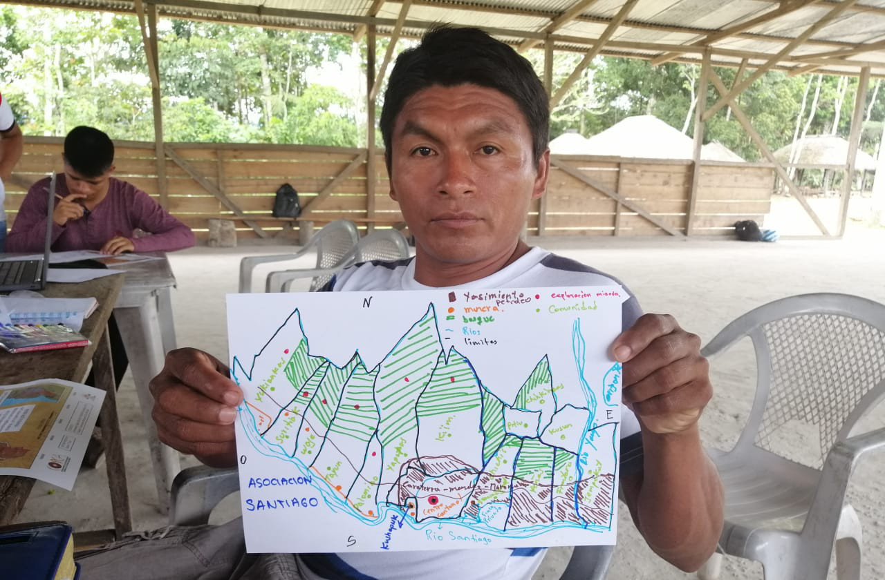
To help address this we have done field work and collected all the geographic information data that is normally handled by the state. These data are going to be very useful for public works. The use of the geographic information system (GIS) by (Shuar) technicians in indigenous territories will serve territorial planning and help to make better use of natural resources.
DM: Do you think it is important that young people in your community learn to make their own maps?
MVS: Education and training in the management of GIS, where young people or communities can choose to manage their satellite data and images, as well as the implementation of technologies is very important, because currently the support is minimal.
Within the three organizations that are part of the “All Eyes on the Amazon” project, we have only 9 monitors. These monitors are not able to provide evidence in the territories quickly, they are not able to gather information in a timely manner. We want communities to provide a lot more training for young people, so that they are more aware of scientific data, as often young people are not up to date with the current know-how.
DM: Can you tell me more about the "All eyes on the Amazon" project you are coordinating?
MVS: All Eyes on the Amazon (TOA) is a project that covers Ecuador, Peru and Brazil. There are several international organizations involved within the TOA program. Here in Ecuador we are working with HIVOS that is managing a Dutch fund in coordination with COICA.
The TOA project has some components that I can mention: 1) radical transparency, which includes the use of technology to collect news; 2) total responsibility, which are communication strategies; and as a last point 3) coordination of educational activities, such as exchange of experiences between different sites in Ecuador, Peru and Brazil. The main objective of the project is to monitor the area of Indigenous Peoples' territories in the Amazon. The project is in the final phase and from the middle of the year it will begin with fieldwork monitoring in the Shuar and Achuar territories of Pastaza and Morona Santiago province. Young people will be trained in GIS management, mapping, drone management, first aid, GPS use and environmental legislation. This will help to carry out monitoring work responsibly within the territory and in the communities.
DM: What technologies are you using together with indigenous knowledge?

MVS: Drones are being used to collect evidence of the environmental impacts that are happening by the extraction of wood, presence of mining companies and construction of roads. At this time within some territories there is the presence of mining concessions by the state. The biggest impact they are causing is river pollution, but there is also a social impact as there is an organizational destabilization by some community members who are not in favour of the companies.
DM: What do you think the world could learn from the Shuar ancestral knowledge and indigenous cosmology?
MVS: In the Shuar world, unlike in the Western world, the Earth has many spaces. For example, we can determine the world above, the world of water, the world of spirits. That is why in the Shuar world we have many places that we have a lot of respect for. We are always asking for respect. Respect is part of the Shuar education; we are always learning and relearning this knowledge. I think the Shuar world is capable of transmitting very sustainable knowledge about the proper use and management of natural resources. For example, how to establish community tourism, how to establish a sustainable food garden or how to build roads.
DM: How are weather patterns and climate changing in the Ecuadorian Amazon and what impacts are these changes having on your community?
MVS: About 10-15 years ago, according to the Shuar world, we kept a calendar where we recorded different weather seasons. Thanks to that, we can now see a radical change in the climate within our territories and in our communities.
The changes that are currently being experienced are, for example high temperature, very hot weather and also a lot of rain. This is causing a lot of concern in places where communities live. Some communities live in high areas and their tributaries dry out because of the heat; other communities live on the river banks and this increases the river flow that causes flooding. The crops of many community members are affected as they are next to the river banks.
According to what we know about the Shuar worldview, there are two seasons to measure time. One is the feminine season, which happens every eight years and matches the floods. The masculine season takes place every 18 years, where the flow of the rivers rises to dangerous levels. These days we may observe that the latter occurs relatively frequently, attesting to changes in the weather and climate.
DM: You are a founding member of the GEO Indigenous Alliance that formed recently in Canberra, Australia. Can you tell me a little more about it?
MVS: I had the opportunity to be part of GEO Week in Australia. There, together with colleagues and friends from different indigenous communities, we formed the GEO Indigenous Alliance to combine modern technology, such as satellite images, with the knowledge of Indigenous Peoples in order to find solutions to the problems currently facing our Earth. We have to act quickly, since the impact and consequences that we, the Peoples of the Amazon, are suffering in our communities are quite critical. We don't want to wait anymore. We need to act!

Diana Mastracci is a researcher at the University of Oxford passionate about finding creative ways to maximize the impact of current technologies to empower social change initiatives among indigenous communities. She has co-designed, together with the Arctic youth, Elders and scientists’ various innovative hackathons and citizen science projects at the interface of traditional and scientific knowledge. She has conducted fieldwork amongst the Iñupiat community in the Alaskan Arctic as well as with the Nenets reindeer herders in the Russian Arctic.
She has worked at the European Space Agency, NASA’s Jet Propulsion Laboratory, the University of Oxford, Citizen Cyberlab, was a visiting scholar at the Cartographic Research Centre at Carleton University and a visiting student at St. Petersburg State University. Diana holds an MA with joint Honours in Social Anthropology and Russian from the University of St Andrews, an MSc in Biodiversity, Conservation and Management from the University of Oxford and a Diploma in Documentary Filmmaking from the EICTV in Cuba.
Follow us on:


