


Blog / Chris Holmes / September 2, 2020

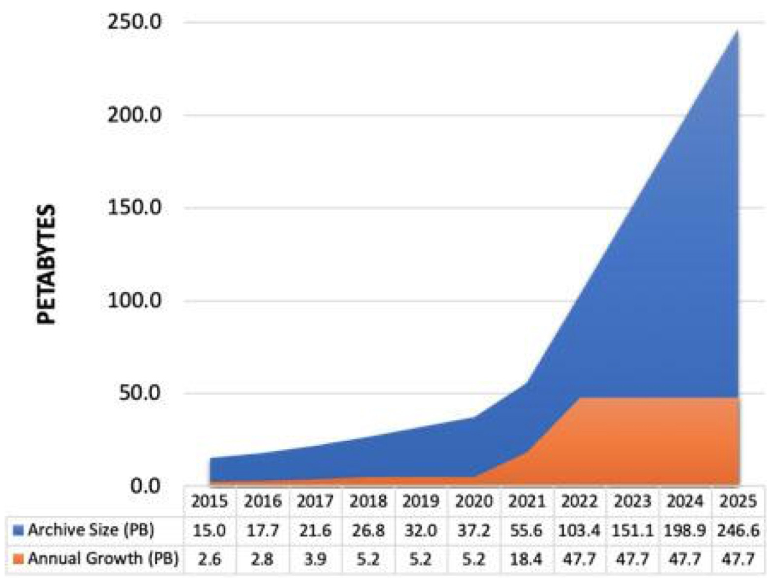
The volume of geospatial data generated from new Earth observation (EO) missions and in situ sensors is growing exponentially, but many of the core patterns of access and analysis of data are still based on legacy approaches. Data may be stored on the cloud, but it is still downloaded to desktop tools or copied to special servers for web access. In the last few years, new patterns now start with the premise that most analysis is done in the cloud, streamed for display to web browsers, making EO more easily accessible and less costly for users around the world.
We call this approach ‘Cloud Native Geospatial’, and it centers around simple open standards for putting data into cloud storage (like AWS S3 or Azure Storage) in a way that diverse tools can stream and process it directly, without having to make their own copy.
On September 8th, next week, we are putting together an ‘Outreach Day’, where you’ll be able to hear from a number of the different organizations embracing Cloud Native Geospatial, learn about data that is available, and dive into various tools that work with the standards. It will be followed by a ‘sprint’, where diverse collaborators will dive in and work together to convert more data to the cloud native geospatial formats. See the Medium post announcing the event for more information.
The core standards are Cloud Optimized GeoTIFF (COG) and SpatioTemporal Asset Catalogs (STAC). COG’s are a way to structure GeoTIFF data for web streaming, and STAC provides simple JSON metadata to enable search and discovery. STAC can work with legacy formats that need to be downloaded, as well as new cloud native multi-dimensional formats like TileDB and Zarr. While these have started as community efforts we are working to get them into the Open Geospatial Consortium (OGC) [a GEO participating organisation] as they mature.
A number of members and partners from the GEO community are moving in a Cloud Native Geospatial direction, indeed Landsat Collection 2 from USGS is fully embracing COG and STAC for their distribution. The ESA FedEO Gateway for CEOS has been working to add STAC support (see their latest progress), and NASA’s Common Metadata Repository has added a STAC interface as well. Commercial data providers, such as Planet and Maxar, and non-governmental organisations including Digital Earth Africa and the World Bank are all also contributors.
Additionally, the three major cloud service providers of AWS, Microsoft and Google are also embracing the Cloud Native Geospatial direction and have recently announced projects with the GEO community - totalling almost 60 new projects. (For more information, discover updates from the GEO-Google Earth Engine Programme here, Microsoft and GEO BON advancing Essential Biodiversity Variables here, and the GEO-AWS Cloud Credits Programme here.)
We’re also doing our best to welcome new people to the community, with ‘Intro Sessions’ that don’t require prior background and encourage questions. And there will be a ‘data labeling contest’ that uses Azavea’s Groundwork to allow anyone with a browser to help make a new COG+STAC dataset. And we’ll have a number of awards and prizes (with nice swag and cash) for participating, with some carved out to encourage contributions by new people and under-represented groups.
So please join us on September 8th!
Sign up directly here, and please spread this post to anyone who you think might be interested.

Chris Holmes is a geospatial technologist and architect whose efforts at the intersection of business and engineering aim to bring the community to more innovative, open, and interoperable solutions. Chris leads Product Strategy at Planet, serves on the boards of the OGC, Baseform and Brave New Software, and is also the first Technical Fellow of Radiant Earth. He founded the STAC community & standard, and leads product management of COGs. Chris previously was a Fulbright Scholar in Zambia, lead development of GeoServer, and served on the boards of the Global Spatial Data Infrastructure Association and The Eclipse Foundation and was a founding board member of the Open Source Geospatial Consortium (OSGeo).
Follow us on:


