


Blog / Jesus San-Miguel-Ayanz / September 28, 2020
Nearly 400 million hectares of natural areas are burnt every year by fires, causing large environmental and economic damages and contributing to the increase of carbon emissions worldwide. The ongoing wildfires in California and recent episodes of the 2019-2020 season in Australia, the Arctic region, and the Amazon among others, show that wildfires are being exacerbated by the already noticeable impacts of climate change.
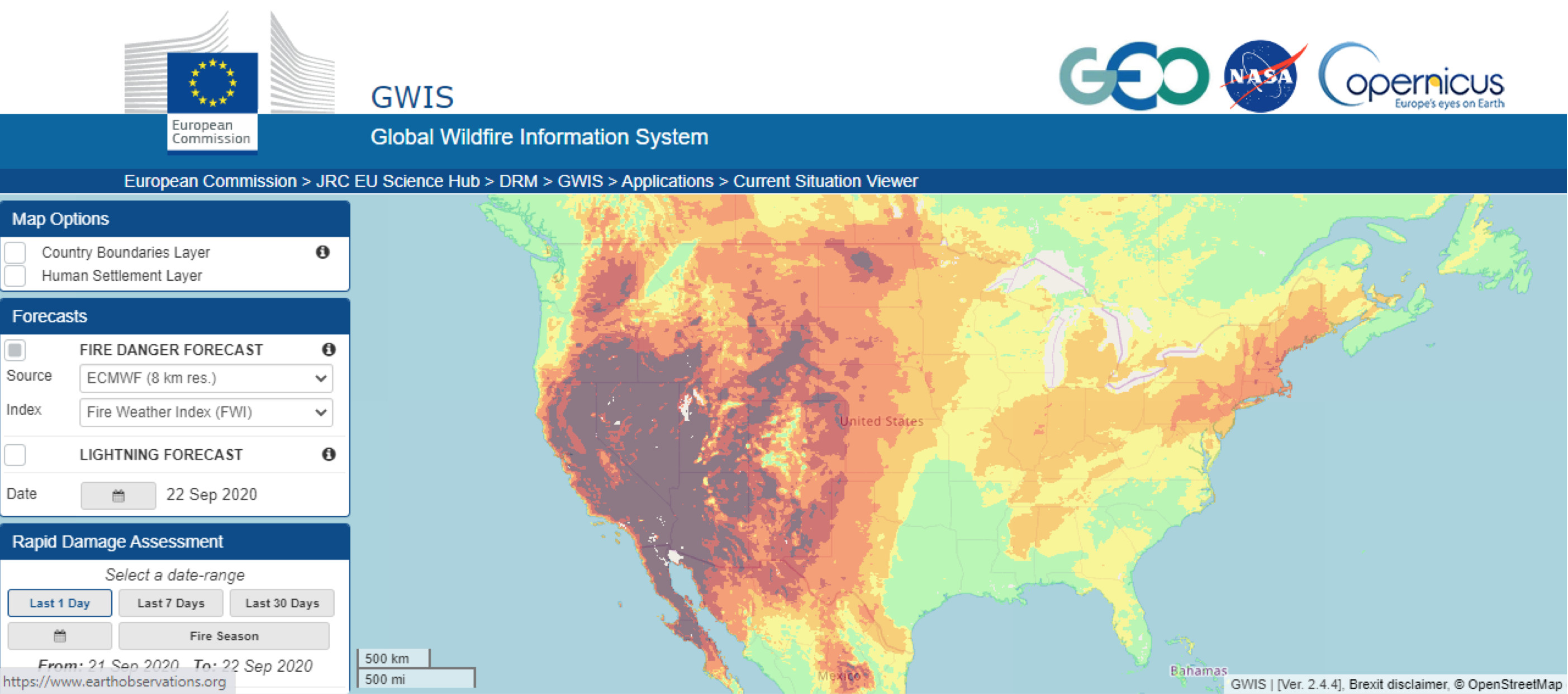
The Global Wildfire Information System (GWIS) is a joint initiative of the Group on Earth Observations (GEO), the NASA Applied Research and the EU Copernicus work programmes. Using advanced methods on data processing for wildfire detection and monitoring, numerical weather prediction models, and remote sensing, GWIS enables enhanced wildfire prevention, preparedness and effectiveness in wildfire management. It is supported by the scientific community and space agencies through the Global Observation of Forest Cover Fire Implementation Team, national research centers, and universities. Furthermore, GWIS provides the first global database of wildfire events for a continuous time frame (between 2001-2019) enabling the analysis of wildfire regimes worldwide and providing the basis for the assessment of potential effects of climate change.
The data and services are readily available through a user-friendly web interface that allows data analysis, visualization and download access on the GWIS portal here.
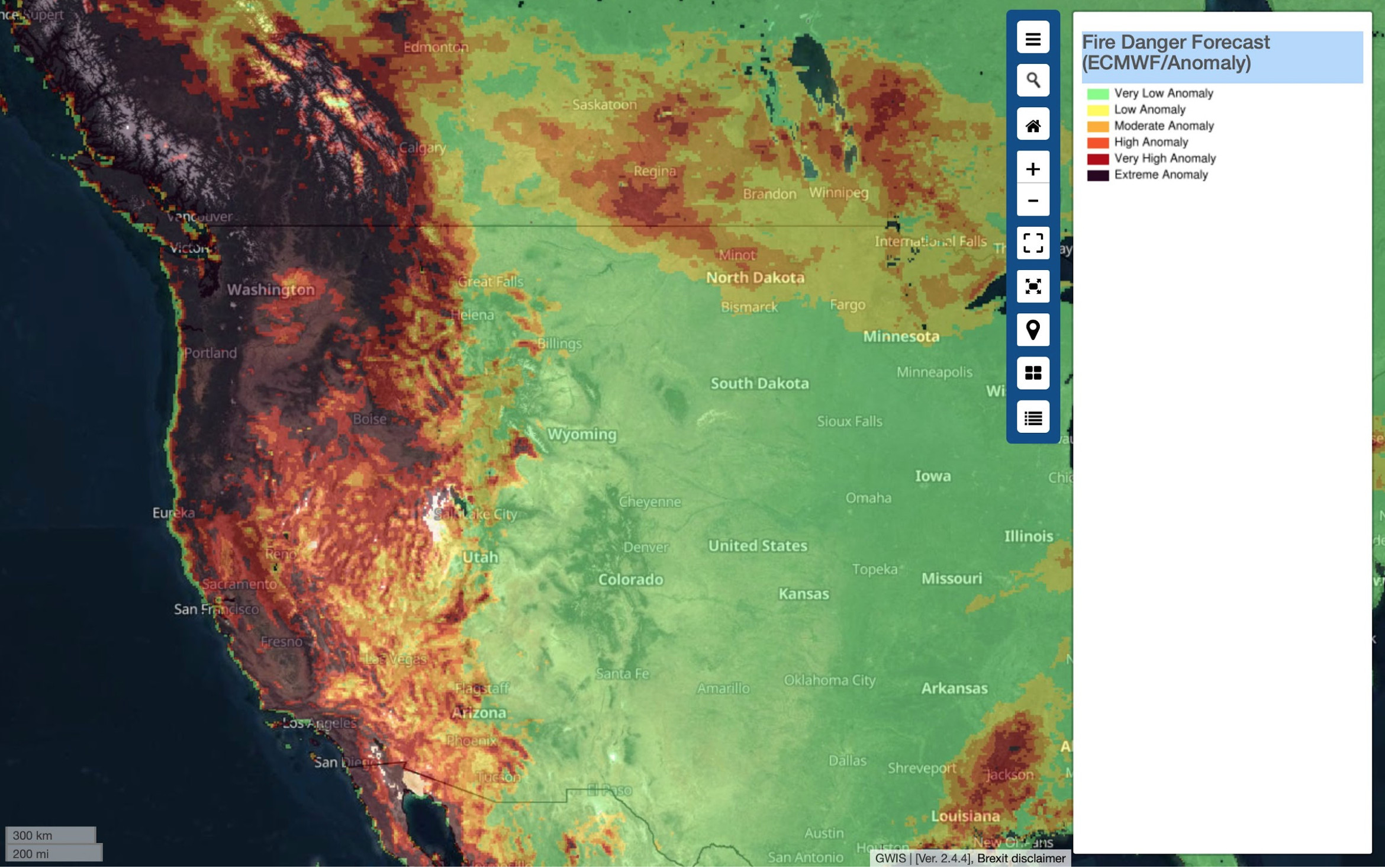
Ultimately, GWIS analyzes the impact of wildfires in terms of fire emissions, damage to human infrastructure and the environment. GWIS is composed of several modules covering the different phases of the fire cycle from the pre-fire to the post-fire stages. In the pre-fire stage, it provides a fire danger forecast up to 10 days in advance of the current date, supporting prevention and preparedness actions. During the crisis or emergency phase, it supports firefighting operations with multiple daily updates of information on active fires, fire extent and progression.
GWIS, its tools and applications are promoted by NASA Applied Remote Sensing Training (ARSET) and the Food and Agriculture Organization (FAO). Results generated from the application of GWIS and wildfire impacts are essential to UN organizations, such as the United Nations Office of Disaster Risk Reduction (UNDRR), as well as support to others such as UN Environment Programme (UNEP) and UN Office for the Coordination of Humanitarian Affairs (OCHA).
At the global level, GWIS is set to be a unique resource supporting developing countries that may not have access to national-level information on wildfires. Unfortunately, those being most affected by disasters more often include middle and low-income and developing countries according to the UN Development Programme (2018). This global open data portal is providing necessary information to those countries that need it most.
GWIS – Support to the Australian government during the critical 2019-2020 bushfire season
Over the 2019-2020 summer, bushfires heavily impacted various regions in Australia and caused widespread harm to people and animals and damage to the economy. Multiple states of emergency were declared across New South Wales, Victoria, and the Australian Capital Territory. During the most critical phase between December 2019 and January 2020, the European Commission established contact with the Australian government to offer support in terms of physical means and analysis of the situation.
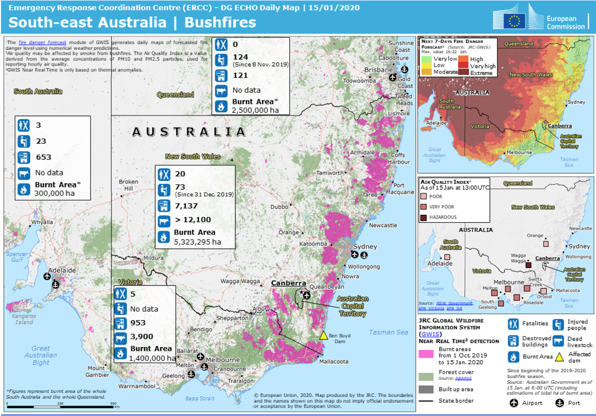
Given the unique capabilities of GWIS to provide synoptic information of the ongoing wildfires and predictions of wildfire danger, the European Commission’s Joint Research Center (JRC) was requested to use GWIS to provide an overview of the situation across the Australian territory (Artes et al. 2020). Furthermore, GWIS was used to support the Australian government through Geoscience Australia by providing daily updates of active bushfires and burnt areas in all the Australian states.
The two maps summarize the information provided by GWIS at different stages of the bushfire season.
The first map, produced on the 15th of January enabled the authorities in the EU to assess the situation in Australia, depict the size and spatial extent of the fires, as well as the number and type of resources that were already deployed by the Australian government for the extinction of the fires. This helped in the assessment of resource capacity in Australia and the type and amount of resources with which the EU could provide in the management of the fires.
The second map, produced once the fires were contained on the 5th of February, provided a synoptic overview of the final state and impact of the fires, while still providing a warning on the wildfire danger forecast that was still critical at that stage.
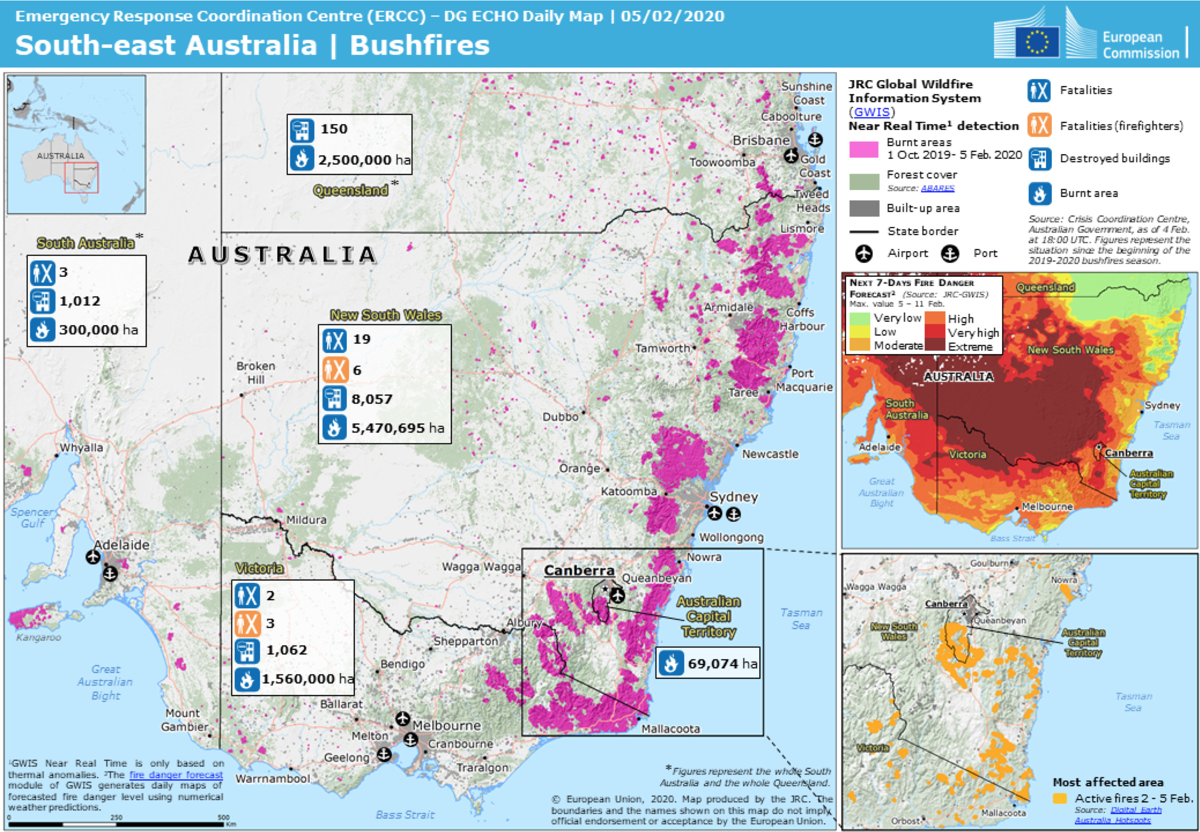
Australia, at the time of the events of this case study, did not have a unified fire information system for collecting or providing information on the evolution of wildfires at national level. Information was obtained through the aggregation of state-level information. The wildfire danger forecast provided by GWIS in the case study provided benefits for wildfire management at the national level as it enabled access to standardized information of wildfire danger in all states, which was accompanied with up to date data on the evolution of wildfires.
This information was simultaneously available to the Emergency Response Coordination Centre (ERCC) and the EU services, including the EU delegation in the country, which facilitated the dialogue between these services at the EU and Australian national level and the assessment of the potential support needed by Australia and available at EU level. GWIS did support the information flow, increase in preparedness and efficient management of wildfire management resources.

Jesus San-Miguel-Ayanz is a senior researcher at the European Commission Joint Research Centre. He coordinates the operation and leads the development of the European Forest Fire Information System (EFFIS) and the Global Wildfire Information System (GWIS). He holds his PhD (1993) and MSc (1989) Wildland Information Science, with majors on Remote Sensing and Geographic Information Systems, Forestry Department, University of California-Berkeley, Berkeley, California, U.S.A. Forest Engineering Degree (1987) by Polytechnic University, Madrid, Spain. Research fellow at the Univ. of California-Berkeley (1989-1992), European Space Agency (1993-1994), EC Joint Research Centre (1994-1996). Publication list available at: https://www.researchgate.net/profile/J_San-Miguel-Ayanz
.Follow us on:


