


Blog / Janet Edwards / October 13, 2020
This past June, the Group on Earth Observations (GEO) established a new international working group for Disaster Risk Reduction (DRR) with over 90 members from around the world. This working group will promote good practice regarding sharing of data and knowledge to improve DRR. It will promote awareness of relevant global policy frameworks, such as UN-GGIM WG-Disasters Strategic Framework on Geospatial Information and Services. It also serves as the primary GEO liaison to UNDRR. Furthermore, the work plan intends to increase the use of Earth observation data for achieving the Sendai Framework’s Global Target E, that aims to substantially increase the number of countries with national and local disaster risk reduction strategies. The work will show how Earth observation data can complement data that governments already have to assess risk, and risk trends over time and to describe and visualize vulnerability and exposure. The GEO DRR working group’s purpose is also to collaborate with other working groups across disaster risk reduction, climate action, sustainable development and urban resilience activities.
Here is a practical example of how Earth observation data can reduce risks.
Tsunami Hazard Exposure Assessment and Forecasting: Applications of GEO data for Fiji’s Tsunami Early Warning System
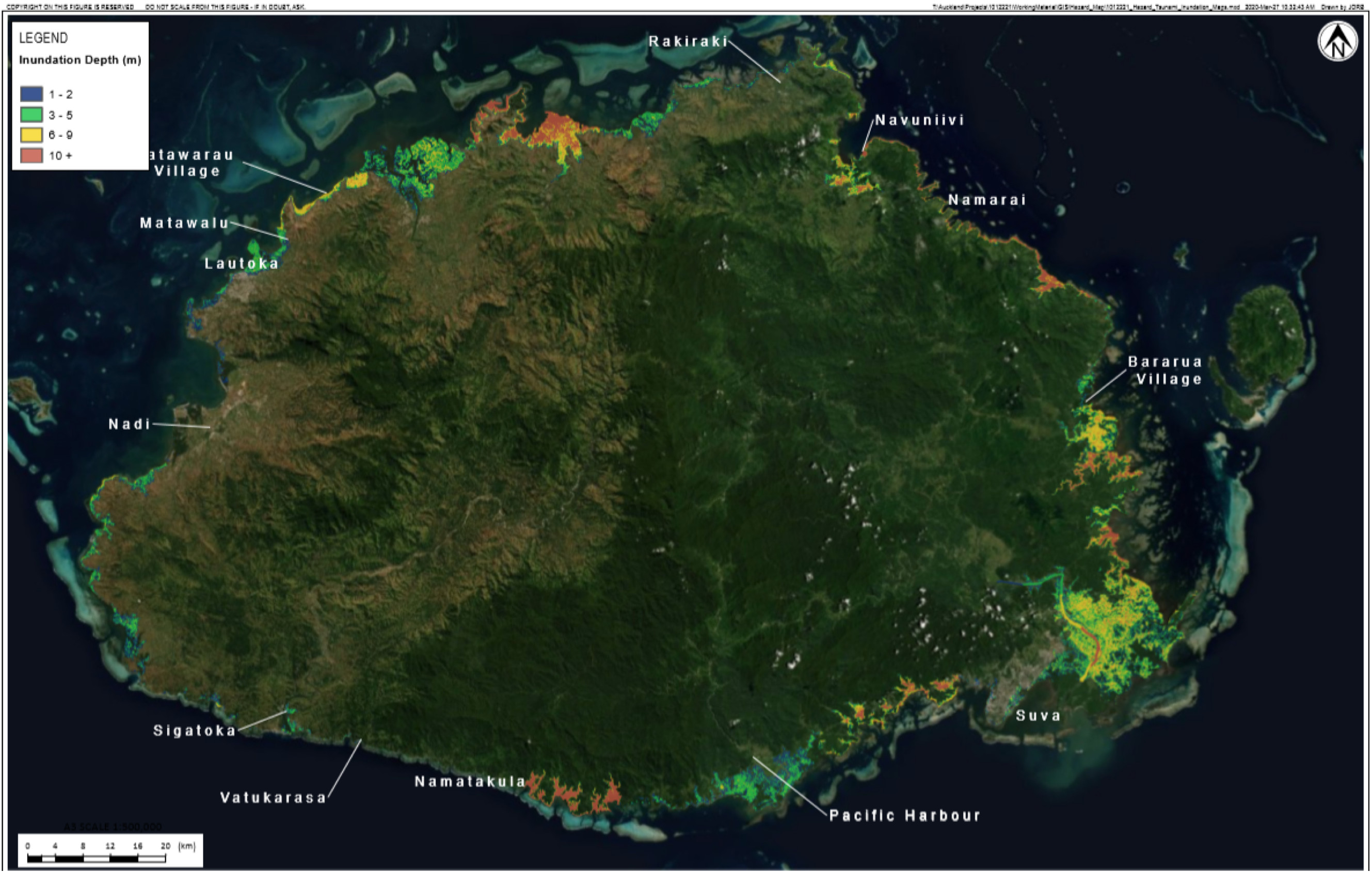
Fiji’s location, on the boundary between the tectonic Australian Plate and the Pacific Plate, makes it vulnerable to many natural hazards, especially tsunamis. Tsunamis are one of the most powerful and destructive natural hazards for coastal communities and can reach the coast in a matter of minutes, meaning that there is very limited time to evacuate to safety. Having a fast tsunami hazard and warning system is critical for a country like Fiji where most of the population lives near the coast, as it helps locals to evacuate quickly when they are at risk
Understanding the need for a nationwide tsunami warning mass notification system, Tonkin + Taylor International (T+TI) stepped up to design the Tsunami Early Warning System (TEWS). The Mineral Resources Department (MRD) uses the TEWS to send warning messages within two minutes. Multiple channels can then share the warning within another minute, making the entire warning process no more than three minutes.
This study applies a mixed methodology approach, using a combination of hydrodynamic models, probabilistic approaches, satellite and remote sensing, geographic information systems and quantitative analysis to determine maximum tsunami heights and exposure to tsunami hazard.
According to Dr. Bapon Fakhruddin, Senior Natural Hazards and DRR specialist at T+TI, the results of this study provide valuable information for the Government of Fiji, specifically the National Disaster Management Office, Mineral Resources Department, the National Tsunami Warning Centre and at-risk communities. This will increase tsunami risk knowledge, will encourage decisive warning times and allow emergency management to make informative decisions about emergency preparedness and response planning.
Janet Edwards from MSB in Sweden, and who leads the subgroup addressing the Sendai Framework monitoring and global assessment stresses that National Focal Points have an important role in informing actors about the Sendai Framework and then sharing their contributions to disaster risk reduction. The GEO DRR working group is a good example of effective collaboration for policy development and technology advancements for disaster risk reduction.

Janet Edwards is a co-chair of the DRR Working Group and lead for Subgroup 2: UNDRR Sendai Framework Monitoring and Global Assessments. She has worked with risk management issues and methods in Sweden since 1995 at the national, international and local levels. She began her employment at the Swedish Civil Contingencies Agency (MSB) in 2009. Her current position is Swedish National Focal Point for the Sendai Framework for Disaster Risk Reduction. Another important part of her work is strengthening political support in Europe for disaster risk reduction. She serves as DRR technical expert for EU projects and is a member of the EU Disaster Loss Data Working Group. She earned her Master’s degree in natural and cultural geography.
Follow us on:


