


Blog / Angélica Gutiérrez / November 16, 2020
Flooding has caused over US$1 trillion in losses globally since 1980 (WRI, 2020).1 Reliable and actionable information is essential for making informed flood risk management decisions. The GEO Global Water Sustainability (GEOGloWS) Initiative and its global partnership that draws from government, academic, public, private, and financial institutions have been working since 2017 to develop this kind of information on every river in the world.
The GEOGloWS ECMWF Streamflow Service is a worldwide application of the global runoff forecasts from the European Centre for Medium-range Weather Forecasts (ECMWF) that transforms runoff into river discharge forecasts for every river of the world. Led by Brigham Young University (BYU) and Esri, it grew out of an effort to build a U.S. National Water Model National in 2015 by the National Oceanic and Atmospheric Administration (NOAA). Following the successful pilot in the USA the NASA/USAID SERVIR Program supported further research and implementation for countries in South Asia in partnership with The International Centre for Integrated Mountain Development (ICIMOD). Additional support from NASA and collaborations with the Regional GEO (AmeriGEO), resulted in pilot applications for Colombia, Dominican Republic, and Central America. Following these initial positive results, the World Bank recognized the GEOGloWS effort as a disruptive technology and supported the expansion of the system globally and Aquaveo’s recent migration of the hydrologic workflow and companion data services from BYU to ECMWF cyberinfrastructure where it will be more reliable and sustainable.
This GEOGloWS ECMWF Streamflow Service is now fully running on ECMWF cyberinfrastructure. The hydrologic data service consists of the same 40-year historical simulations from ECMWF's ERA5-Land reanalysis and 15-day ensemble forecasts produced daily for the Copernicus Emergency Management Service Global Flood Awareness System (GloFAS). The difference is that the model runoff in GEOGloWS is mapped to watersheds globally at about 150 sq. kilometers and then routed through river networks to produce a forecast for each river in the world.
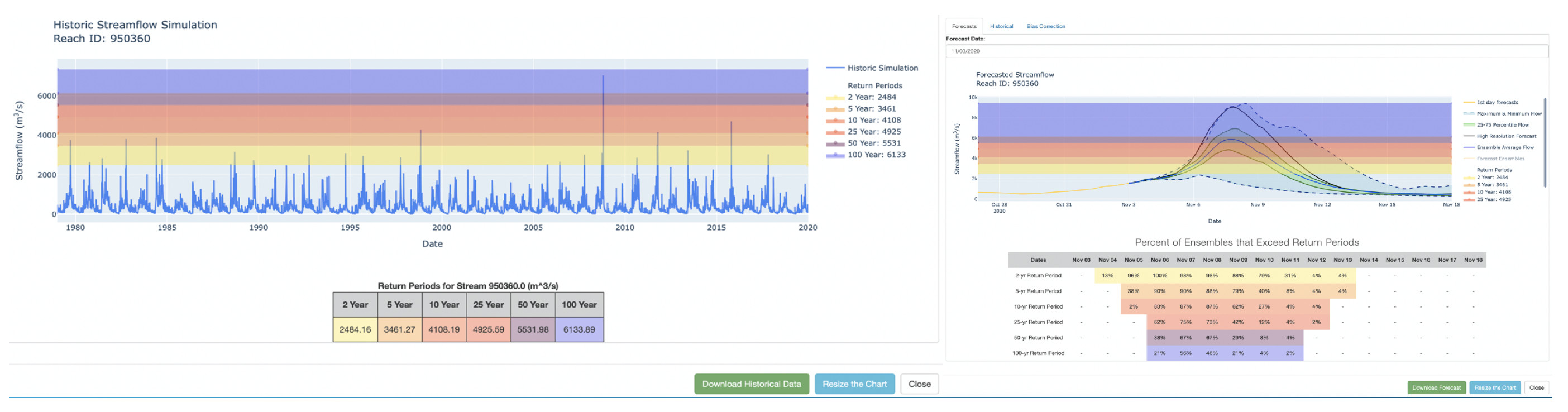
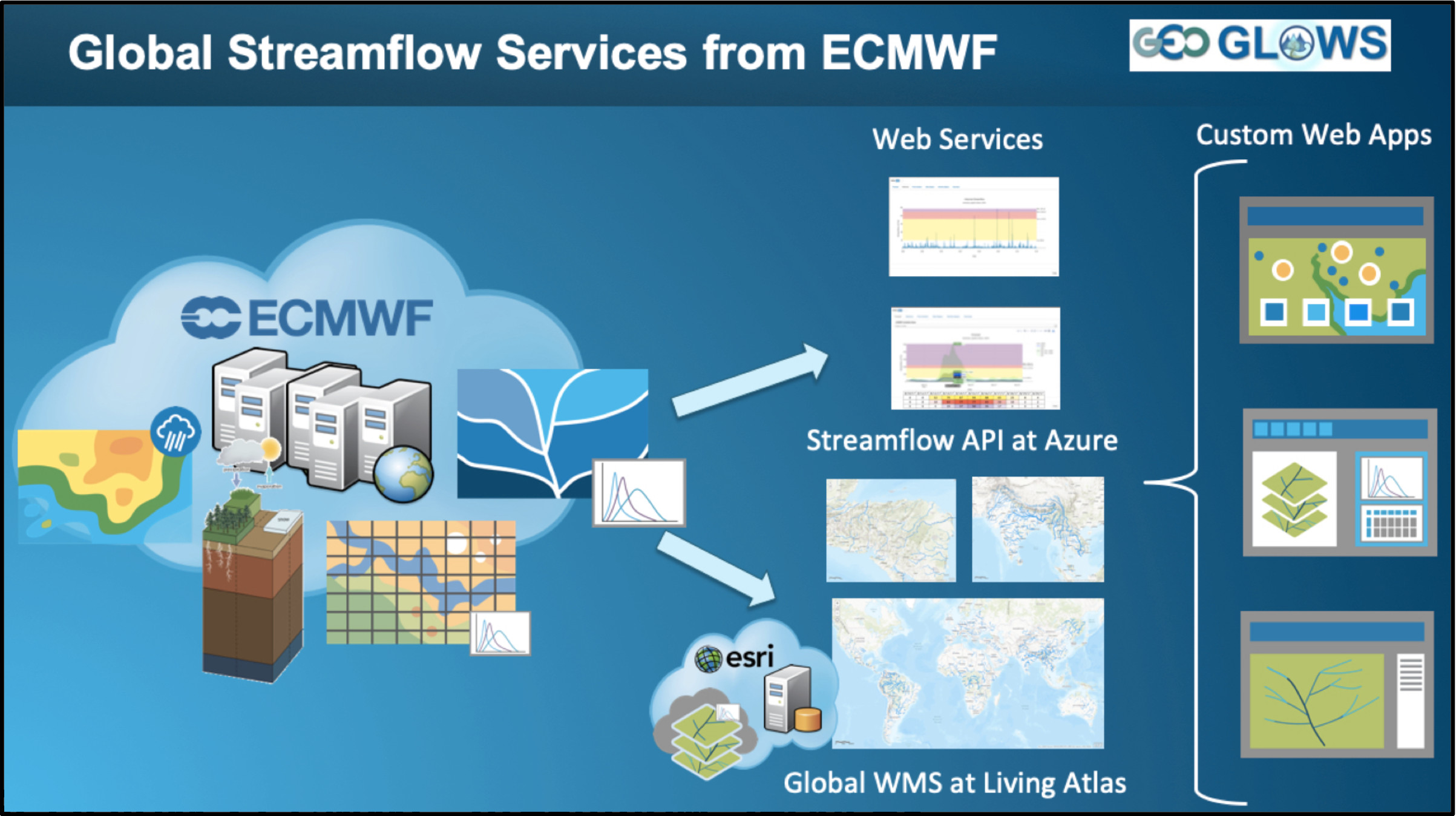
Both the forecast and historical simulation are made available as data services through a Representational State Transfer /Application Program Interface (REST API)2 and extended through the python geoglows package available at PyPI and Conda. Besides the data access service, Esri has developed a web mapping service hosted on the Esri Living Atlas, which can be animated and indicates where high flows and extreme events are possible in space and time. These free and open services can complement local efforts to provide information where little or none exists and have been designed to address communities' critical needs worldwide.
The GEOGloWS global streamflow service’s team developed the GEOGloWS hydroviewer to demonstrate the use of the Esri mapping and animation service and historical/forecast data services.

Customized applications have been implemented in Central America, within the SICA-CRRH/Centro Clima Platform, where the National Hydrological Services (NHSs) from seven countries access daily forecasts and historical simulations, and leverage the global forecast applying bias correction methodologies with their in-situ streamflow observation data. Similar customizations have also been developed for Colombia (IDEAM), the Dominican Republic (INDRHI), the International Centre for Integrated Mountain Development (ICIMOD) with applications for Nepal, Bhutan, Bangladesh, and other regional member countries of the Hindu Kush Himalayas.
The GEOGloWS Streamflow Services were migrated from the research environment at BYU and its Microsoft AI for Earth grant to ECMWF, where it is now run and will be maintained by Aquaveo, a commercial partner in GEOGloWS. The GEOGloWS global partnership will continue advancing the science and technology developments to address water sustainability challenges through these and other services.
1 https://www.wri.org/news/2020/04/release-new-data-shows-millions-people-trillions-property-risk-flooding-infrastructure
2 REST Representational state transfer is a software architectural style that defines a set of constraints to be used for creating Web services. An API (application program interface) is a set of rules that enables different programs to communicate with one another.

Angélica Gutiérrez is a Lead scientist at NOAA, and she serves as Chair of the AmeriGEO regional and chairs the Global Water Sustainability (GEOGloWS) Initiative. Dr. Gutierrez is a member of the Ambassador’s Water Experts Program (AWEP), a Program in support of the U.S. Presidents Global Water Strategy. In 2019, Dr. Gutierrez received the GEO Individual Excellence Award, for being a driving force behind AmeriGEO, the regional initiative of the intergovernmental Group on Earth Observations (GEO) in the Americas, and for leading GEOGloWS activities, where she has made exceptional contributions to the work of GEO by improving water sustainability in multiple countries, and for pioneering scientific and regional collaboration.
Follow us on:


