


Blog / Diana Mastracci / August 9, 2021

The GEO Indigenous Hack4Covid event held in June 2021 and organized by the GEO Indigenous Alliance in collaboration with Space4Innovation and the GEO Secretariat, aimed to co-create EO-based solutions with and for Indigenous Peoples from around the world. After the hack, winners received mentorship and guidance to turn their prototype into reality working in partnership with the Indigenous communities.
One of the winning entries addressed the "Namunyak (Blessing)" challenge, submitted by Titus Letaapo co-founder of the GEO Indigenous Alliance and member of the Samburu tribe, Kenya, and was submitted by an international team of young professionals: Yoanna Dimitrova (anthropologist from Bulgaria working in the UK), Lucandrea Mancini (rocket scientist from Italy), Miroslawa Alunowska (engineer and AI specialist from Mexico working in the UK), Nicolas Marin (ecologist from Colombia working from Australia), and William Booth (software developer from the UK).
We interviewed The Symbols Maps team and Titus Letaapo to learn more about their innovative app:
Congratulations on winning the GEO Indigenous Hack4Covid competition in June! Can you tell us about the innovative concept behind your app?
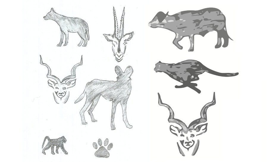
Indigenous-led mapping has become an indispensable tool in the struggle of Indigenous peoples to claim their rights to land and resources. The aim of the Namunyak App was to co-design a tool with and for the Samburu community to allow them to participate and contribute to the decision-making processes regarding their lands. The Samburu are a semi-nomadic community living in north-central Kenya. At the beginning, they were interested in ‘an application that will allow them to map their lands using a unique combination of three words in their local language using local knowledge’. Inspired by the chess notation, team-member Lucandrea Mancini suggested using a combination of the first letters of the words, however, subsequently instead of letters we used symbols.
This idea has been fundamental for the project as it radically changes the way mapping has been previously done in the area. As a result, and because of the oral tradition of the Samburu language, the Namunyak App aims at creating a new way to label places on a map using local, culturally relative symbols. The app encodes the geographical coordinates predominantly of the Samburu County but also of neighbouring areas, and translates them into four symbols which have been hand drawn by a local artist - Stephen Lesiakono. We further digitised the symbols and tried to keep as close to the original drawings as possible (see photos attached). We believe that the Namunyak App will empower the Samburu and give them a sense of ownership and control over their land through visualisation, documentation, education and easier communication.
Titus Letaapo, what impact can this app have for the Samburu tribe?
The application will have a hugely positive impact on the Samburu tribe in few different ways:
Symbols Map team, what were the biggest challenges you faced and how did you overcome them?
One of the biggest challenges we faced at the beginning was how to even start developing this project. How could we turn this concept into reality? None of us had any experience in designing a project like this. It was very important for us to co-design the app in a respectful way based on mutual trust and respect. We managed to do this by constantly consulting with Titus Letaapo and what he and Samburu thought was important for the app. In terms of the technical aspects of the app, we are very lucky to have Will on board as we could not have achieved this success without his support. In addition, we reached out to some renowned academics whose feedback made us more critical of certain issues and made us think about things we would not have thought of otherwise. We also did a lot of research into the CARE Principles of Indigenous Data Governance as well as in previous studies to gain a better understanding of the cultural and technical aspects.
Another challenge we had to overcome was of course COVID -19 as well as the fact that our team is spread across four different time zones. Despite this, we successfully managed to work remotely and as a result have become more creative in the way we communicate with each other. Online platforms such as Asana, Zoom and WhatsApp have been essential in this process. Communication, collaboration and co-creation with Titus Letaapo and the Samburu were among our most important and cherished principles.
What support have you received from the GEO community?
We are extremely grateful for the support and training we received from the GEO community. Diana Mastracci has been our mentor and a person to consult with on various questions that came along. She has given us her invaluable advice on how to best approach certain topics throughout the project. She has been extremely encouraging and supportive, especially when it comes to networking and gaining visibility by participating in different conferences and activities. We further received a training session from the Google Earth Outreach team at the beginning stages of our project which helped us explore initial developing opportunities and offered us valuable guidelines to work along.
Titus Letaapo, what are your plans for the future to ensure the sustainability of the app and what support is needed to achieve this?
The app will fully be owned by the Samburu people. We have our own County Government, which in consultation with the Samburu elders will support the app by allocating funds for sustainable solutions to the problems they are facing. For example, through land use planning, some areas will be designated as tourist and wildlife areas, especially if tourism is an income generator for the community, thus helping the app to benefit future generations.
About the team:
Yoanna Dimitrova:

I am a Master’s student in Anthropology and Archaeology who is dedicated to exploring new and novel ways in which I can combine these two disciplines, by simultaneously involving Indigenous communities into writing their own history, taking care of their own heritage and taking their own land and resource management decisions. The Namunyak App project deeply resonates with my aspirations in finding ways to decolonise the anthropological toolkit, as well as to help and engage with community-needed solutions. I am evermore determined to continue managing this project and develop it further.
Lucandrea Mancini:

I am a PhD student in Aeronautical and Space engineering, focused on launch vehicles design. Since I was a child, I showed analytical skills and love for space and mathematics. My hunger for knowledge leads me to constantly expand my cultural background. I have a Bachelor’s degree in Aerospace engineering and a Master’s degree in Space and Astronautical engineering. I took part in this project because I wanted to input my knowledge of space and mathematics into the field of mapping in which I could improve peoples’ lives.
William Booth:

I am a software engineer from Norwich, England, currently working as a .NET developer at Aviva. I got involved in this project to provide technical expertise in software development and to broaden my skill set as a mobile developer. Contributing my time towards a charity project as a developer is not something I have done before but I greatly enjoyed and intend to do again.
Nico Marin:

I am a recent BSc graduate in Environment and Sustainability and before that, I used to study Ecology. My studies, background, and the way I have been raised have encouraged me to take part in projects where there is co-construction for the improvement of people´s lives. I truly believe this is the aim of the project and achieving it with this great team is an honour. The potential of this project is in a way still to be discovered, however, it seems to be a tool that can benefit a lot of communities in the world, which might have a similar situation. Participating in this kind of project is a passion of mine.
Titus Letaapo:

Titus Letaapo is a champion of the community-based conservation model in Northern Kenya, having over 20 years experience in conservation and community development. Now, he oversees and supports the Namunyak Community Conservancy and acts as a Director of Community and Programs at the Sarara Foundation (TSF). In this capacity, Titus has helped develop successful conservation strategies, spearheaded collaboration between the County Governments and communities, and played a key role in promoting peace between the different ethnic groups in Samburu and neighbouring communities. His work is not only helping create the conditions for sustainable socio-economic development, but also helping to conserve and protect critically endangered species including black rhino, elephant and Grevy’s zebra.
TSF is a Kenyan-based NPO working to support a long-term paradigm shift design to catalyze a healthy, resilient and prosperous landscape in which both Indigenous people and wildlife can thrive for multiple generations to come.
Link for the presentation at the GEO Indigenous Summit 2020 (Lightning Talk):
https://www.youtube.com/watch?v=XyiyV_h9gws
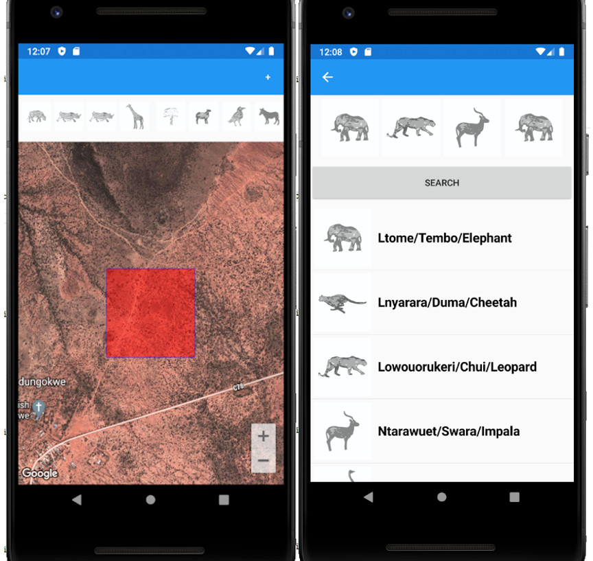
Screenshots of the app, which is now ready for beta testing and launching.
Diana Mastracci currently works as a communications consultant for the GEO Secretariat and is the International Strategic Liaison for the GEO Indigenous Alliance . She founded Space4Innovation to find creative ways to maximise the impact of current technologies and EO data to empower social change initiatives. She has worked at European Space Agency, NASA’s Jet Propulsion Laboratory, the University of Oxford, Citizen Cyberlab, as a visiting scholar at the Cartographic Research Centre Carleton University and as a visiting student at St Petersburg State University. Diana holds an MA with joint Honours in Social Anthropology and Russian from the University of St Andrews, an MSc in Biodiversity, Conservation and Management from Oxford University and a Diploma in Documentary Filmmaking from EICTV in Cuba.
Follow us on:


